
Mars Global Surveyor
Mars Orbiter Camera
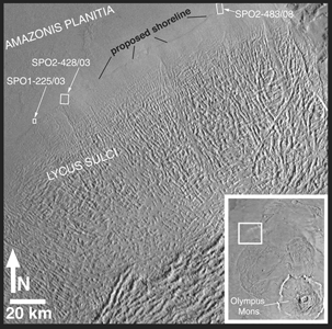
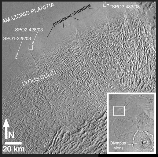
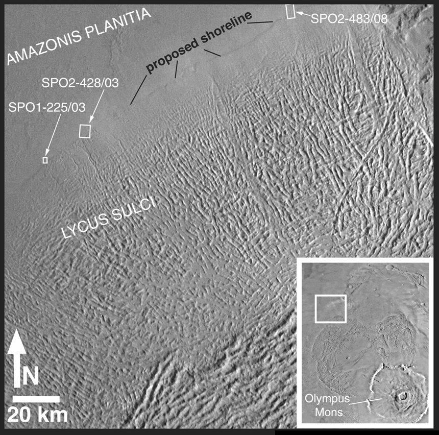
Mars Shoreline Tests: Contact between Lycus Sulci and Amazonis Planitia
MGS MOC Release No. MOC2-180, 1 October 1999
MOC2-180a: Lycus Sulci/Amazonis Planitia Context
"Lycus Sulci" is the name of a region of hills and ridges located north and
northwest of the famous giant volcano, Olympus Mons (see inset, above).
Viking images of the area where the western margin of the Lycus Sulci meets
the smoother Amazonis plains (upper left in the figure above) led some
researchers to conclude that the two surfaces were in contact along a cliff.
The proposed cliff faces toward the smooth plains, and thus it was
suggested that this might be the kind of cliff that forms from erosion
by waves in a body of water as they break against a coastline.
During the first year that Mars Global Surveyor (MGS) was orbiting the
red planet (1997-1998), the Mars Orbiter Camera (MOC) acquired three
high-resolution images along the contact between the Lycus Sulci hills and
the Amazonis plains. The location of the portion of each image that is
illustrated below is shown in this figure by a small, white box identified
by the archival image number (e.g., "SPO2-428/03" refers to the 3rd
image taken on the 428th orbit during the Science Phasing Orbits 2 phase
of the MGS mission). The regional context view shown here is a portion
of Viking orbiter image 851A29; its center is near 32°N, 114°W
and it is illuminated from the right.
For a higher-resolution view (755 Kbyte),
CLICK HERE.
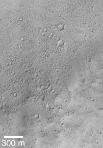
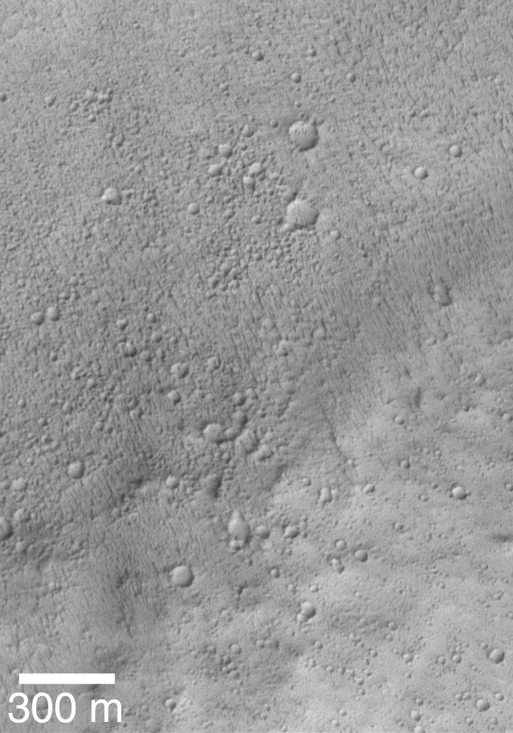
MOC2-180b: MOC Image SPO1-225/03 Shoreline Test
This picture is the first MOC high resolution image that showed
the contact between the Lycus Sulci uplands and Amazonis Planitia
lowlands. In this subframe of MOC image SPO1-225/03, Amazonis
and Lycus Sulci are separated by a subtle rise that runs diagnonally
across the scene from near the lower left toward the upper right.
The Amazonis plains are toward the top of the picture, the Lycus Sulci
uplands are toward the bottom. Both surfaces have been cratered by small
meteoroid impacts. The Amazonis plains surface has many small, nearly
parallel ridges
that may have formed by wind erosion. These ridges are not found on the
Lycus Sulci surface. None of the features seen in this image look like
typical seashore landforms found on Earth--i.e., there are no
beaches, windblown coastal dunes, or even the wave-cut cliff that was
thought to exist on the basis of previous Viking images. The picture is
illuminated from the lower right and was acquired in April 1998.
For a higher-resolution view (625 Kbyte),
CLICK HERE.
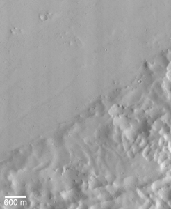
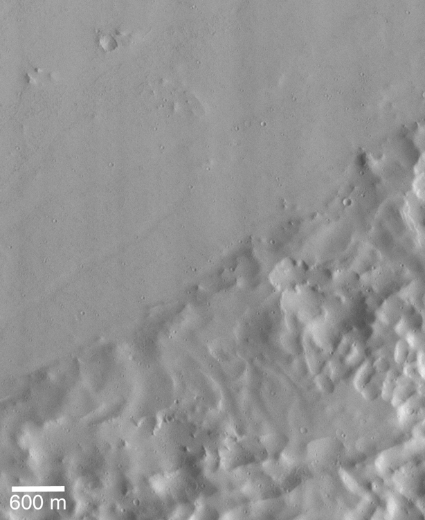
MOC2-180c: MOC Image SPO2-428/03 Shoreline Test
As in the previous picture, Lycus Sulci and Amazonis Planitia are
shown here separated by a rise that runs diagonally across the scene
from near the lower left toward the upper right. This picture is
a subframe of MOC image SPO2-428/03, taken in July 1998. The Lycus
Sulci uplands here are more roughly-textured than in the previous image,
and the flat Amazonis plains appear to be more smooth and lack the small
parallel ridges seen in the earlier view. The lack of the small ridges
might be real, or they might be present but cannot be seen because this
picture has a lower resolution than the previous one. This image, too,
shows that the contact between Amazonis and Lycus Sulci is not a cliff,
and once again there are no features that can be unambiguously identified
as coastal landforms. The picture is illuminated from the right.
For a higher-resolution view (1.1 Mbyte),
CLICK HERE.
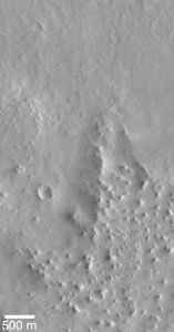
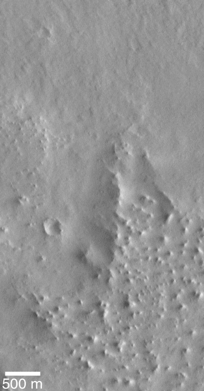
MOC2-180d: MOC Image SPO2-483/08 Shoreline Test
This is the third MOC image obtained during the first year of MGS
operations that shows the contact between Lycus Sulci and
Amazonis Planitia. This picture, a subframe of SPO2-483/08, was
taken in August 1998. The Lycus Sulci uplands at this location
dominate the lower half of the picture, while the Amazonis plains
cover the upper half. The uplands here exhibit many small buttes
(bumps or knobs in lower right of the scene), and the contact zone
between the upland and lowland includes a triangular-shaped ridge
(center/right). As with the earlier views of the contact between
Lycus Sulci and Amazonis, no features of obvious origin by coastal
processes (e.g., erosion by waves crashing against a shore)
are seen. The image obtained by clicking on the icon is the highest
resolution view. The scene is illuminated from the right.
For additional MOC image tests of proposed martian shorelines,
see the following:
Malin Space Science Systems and the California Institute of Technology
built the MOC using spare hardware from the Mars Observer mission. MSSS
operates the camera from its facilities in San Diego, CA. The Jet Propulsion
Laboratory's Mars Surveyor Operations Project operates the Mars Global Surveyor
spacecraft with its industrial partner, Lockheed Martin Astronautics, from
facilities in Pasadena, CA and Denver, CO.
 To MSSS Home Page
Contact: info@msss.com