
MGS MOC Release No. MOC2-181, 1 October 1999


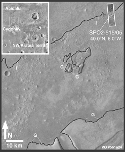
The context image on the left includes several dark lines, some of which are labeled I and some are labeled G. These dark lines were proposed in previous, peer-reviewed scientific papers to be possible ocean shorelines located along the margins of the martian northern plains. Line I was called the "Interior Plains Boundary," and line G was called the "Gradational Boundary." The MGS MOC high resolution image was targeted such that it would examine the nature of line I, the Interior Plains Boundary.
The figure on the right shows the MOC high resolution view. The picture on the left side of the figure is the full MOC image and the white box indicates the location of the expanded view to the right. In the expanded view (the center of the figure on the right), the location of line I--the proposed shoreline--is shown by a dashed curve. The dashed curve follows a subtle, shallow trough. None of the types of coastal landforms common on Earth--such as a beach, wave-cut cliff or terrace, or coastal dune fields, are seen at this location. If an ocean had once been present, then the water would have covered the top 2/3 of the expanded view--i.e., water would have lapped up against the rounded mounds in the lower 1/3 of this picture. Instead of coastal landforms, the MOC image exhibits a dark surface in its upper 1/3. The dark surface covers older, rounded hills and has a low, lobate escarpment along its southern margin. This escarpment faces south--that is, it faces toward the once-proposed coastline. In other words, the escarpment faces in a direction opposite of what would be expected for a coastal environment.
The contex picture uses Viking orbiter image 561a24 as a base. This Viking image is illuminated from the left. For a higher-resolution view of the context image (870 Kbyte), CLICK HERE.
The MOC high resolution image is illuminated from the left/upper left. For a higher-resolution view of the narrow angle camera figure (485 Kbyte), CLICK HERE.
Malin Space Science Systems and the California Institute of Technology built the MOC using spare hardware from the Mars Observer mission. MSSS operates the camera from its facilities in San Diego, CA. The Jet Propulsion Laboratory's Mars Surveyor Operations Project operates the Mars Global Surveyor spacecraft with its industrial partner, Lockheed Martin Astronautics, from facilities in Pasadena, CA and Denver, CO.
Contact: info@msss.com