 |
|
|
 |
The ocean hypothesis envisions that the martian northern lowlands were once covered by either a single, continuous body of water or incompletely covered by a series of smaller seas connected by spillways. The ocean hypothesis is very important, because the existence of large bodies of liquid water in the martian past would have a tremendous impact on ancient martian climate and might also have implications for the search for evidence of past life on the planet. Prior to the ocean hypothesis, most of the data gathered in the 1960s and 1970s seemed to suggest that Mars had a very dry past, not a wet one. Understanding how much water was once present on the red planet is critical to unravelling the planet's entire history.
Scientists usually present their observations, conclusions, and new hypotheses in papers that are written for scientific journals. These articles are commonly subjected to a process known as "peer review". Before an article describing a body of research is published, the journal editor sends it out to several other scientists who are usually experts on the subject of the paper. These scientists review the paper, examine it for flaws and/or provide suggestions for improving the work and its presentation. If the reviewers raise significant questions or indicate that revisions to the paper are necessary, then the editor returns it to the author for improvement and clarification. Sometimes, after the paper is revised, the editor might send it out for an additional review. Eventually (unless the paper is rejected), the editor is satisfied that the author has presented the work well and that the paper represents an important advance in its scientific field, and the paper is published.
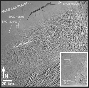
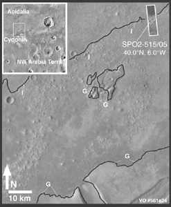
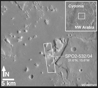
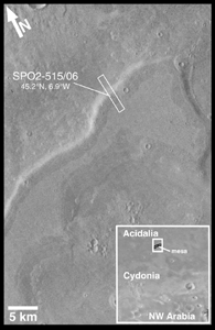
One of the key elements of the Mars ocean hypothesis has been the identification and publication of possible shorelines around the margins of the martian northern plains. Only a few papers have been published in peer-reviewed journals that provide maps and figures that describe the proposed ancient coastlines of Mars. During the Aerobraking and Science Phasing Orbits portion of the MGS mission (September 1997 to September 1998), the MOC science team devoted about 2% of its observations to taking images of the proposed and previously published shorelines.
Looking for ancient shorelines is not easy. On Earth, it is often difficult to identify the coast of an ancient lake, sea, or ocean using high resolution satellite or aerial photographs. Ancient shorelines may be discontinuous because they have been modified after the body of water dissappeared (e.g., they can be covered by lava or sand dunes), or may be difficult to see because of either very steep or very shallow topography. People who map ancient shorelines on Earth find that it is very important to visit the site in person to confirm any suspected shoreline seen in a photograph. Often, what makes a shoreline appear in a photo is a variation in vegetation that results from the way plants grow in soils of different permeability and porosity--both of which can be a function of the size of sediment grains and compaction of the sediment along an ancient coastline. Obviously, on Mars the problem of identifying ancient coastlines is hindered by the lack of vegetation and the fact that people presently cannot visit the planet and check the landforms in person.
Despite the difficulties of finding and confirming the presence of ancient shorelines in aerial and satellite pictures, MGS MOC images of places that were already proposed--on the basis of Viking orbiter images--to be ancient coastlines were examined and the results of that examination described in a paper recently published in the American Geophysical Union's journal, Geophyscical Research Letters. The figures and captions presented here describe and elaborate upon results presented in this paper, titled, "Oceans or Seas in the Martian Northern Lowlands: High Resolution Imaging Tests of Proposed Coastlines," by MOC scientists Michael C. Malin and Kenneth S. Edgett.
Prior to the identification of possible shorelines in the mid-1980s, no evidence had been found to stimulate the idea that Mars once had seas or oceans. Rare discussions of large bodies of water on Mars were considered highly speculative at best. The purported shorelines changed this: if shorelines existed on Mars, then bodies of water must have once existed to form these features. One would think that the converse must also be true: if the shorelines did not exist, then the "evidence" used to suggest that Mars had seas or oceans did not exist, and thus the idea that such seas or oceans once existed could be forgotten. However, once a speculative interpretation is proposed, it is often very difficult to subsequently prove that the thing proposed doesn't exist (a process called "proving the negative"). The MGS MOC images from 1997 and 1998 do not show any obvious or unambiguous coastal landforms where previous researchers--working with lower spatial-resolution Viking images--indicated that shorelines might occur. If these peer-reviewed and published shorelines never existed, then the oceans and seas that were proposed to have created the putative shorelines also never existed. But once proposed, it is not possible to disprove such ideas with any certainty. Thus, the idea that Mars at one time had seas or oceans cannot not be ruled out, but the basis for the 1980s "ocean hypothesis" appears to have been incorrect. Thus, these new MOC results can not be viewed as anything more than a contribution to the on-going study of Mars and the nature of its ancient past, albeit one that challenges some popular views.
For additional information, click on the icons below to see pictures
that illustrate the MGS MOC results. Also read the Malin Space Science
Systems PRESS RELEASE on the same subject.
Malin Space Science Systems and the California Institute of Technology built the MOC using spare hardware from the Mars Observer mission. MSSS operates the camera from its facilities in San Diego, CA. The Jet Propulsion Laboratory's Mars Surveyor Operations Project operates the Mars Global Surveyor spacecraft with its industrial partner, Lockheed Martin Astronautics, from facilities in Pasadena, CA and Denver, CO.
