![]()
![]()
![]()
![]()
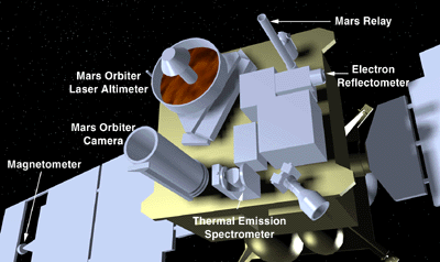 |
Mapping operations will begin in mid-March 1998 and last until January 2000. During those two years, transmission rates as fast as 85,333 bits per second will allow Mars Global Surveyor's six main scientific instruments to send nearly 83 gigabytes of data back to Earth. The enormous amount of data, enough to fill over 130 CD-ROMs, will contribute to an extremely comprehensive study of the Martian atmosphere, surface features, mineral distribution, and magnetic properties. Click on the red bar containing the title of the science instrument for more information regarding that specific instrument.
![]()
The camera will produce a daily wide-angle image of Mars similar
to weather photographs of the Earth shown on the nightly news. In
addition, the narrow-angle lens will capture images of objects as
small as 1.5 meters across.
![]()
The laser altimeter will bounce beams of light off of the surface
to measure the heights of mountains and depths of valleys.
![]()
The thermal emission spectrometer will scan for heat emitted from
Mars to study the atmosphere and to map the mineral composition
of the surface.
![]()
The magnetometer will study the magnetic properties of Mars to
gain insight into the interior of the planet.
![]()
The relay antenna will receive data transmitted to Surveyor from
future NASA spacecraft that will land on the Martian surface.
![]()
An analysis of radio signals sent to Earth from Surveyor will
reveal the precise shape of the planet and structure of the
atmosphere.