
Mars Global Surveyor Mars Orbiter Camera Release:          MOC2-76
Mars Global Surveyor Mars Orbiter Camera Image ID:         568174924.8003
                                                           P080-03
CAPTION
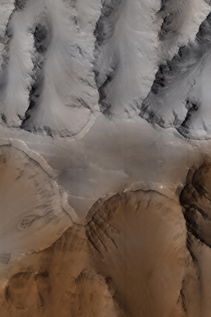
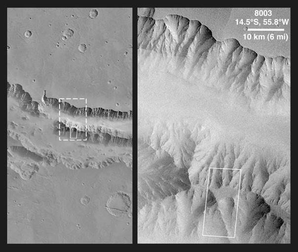
One of the most spectacular results of the Mars Global Surveyor (MGS) Mars Orbiter Camera (MOC) mission thus far has been the observation of many layered outcrops in various locations across the surface of the red planet. On Earth, layered rocks are used by geologists to decipher the history of the planet's surface over time scales of billions of years. Layered rock on Mars might one day offer the same opportunity for intense examination by geologists working "in the field."The thickest sequences of layered material are exposed in the deepest canyons--that is, in the walls of the Valles Marineris--a system of canyons and troughs that would stretch from Los Angeles to New York if it occurred on Earth. MOC image 8003 (above) shows a flat-topped ridge in the middle of Coprates Chasma in the eastern Valles Marineris system. The highest terrain in the image is the relatively smooth plateau near the center of the frame. Slopes descend to the north and south (upper and lower part of image, respectively) in broad, debris-filled gullies with intervening, rocky spurs. Multiple rock layers, varying from a few to a few tens of meters thick, are visible in the steep slopes on the spurs and gullies. Layered rocks on Earth form from sedimentary processes (such as those that formed the layered rocks now seen in Arizona's Grand Canyon) and volcanic processes (such as layering seen in the Waimea Canyon on the island of Kauai). Both origins are possible for the martian layered rocks seen in this image. In either case, the total thickness of the layered rocks seen in this image implies a complex and extremely active early history for geologic processes on Mars.
MOC image 8003 was taken on January 1, 1998. The image was also the subject of two earlier MGS MOC releases, the first on February 2, 1998 and the second on March 13, 1998. It was also featured on the cover of the journal, Science, for its March 13, 1998, special issue on the results of Mars Global Surveyor. The image was taken as a monochrome (black and white) picture; color was derived from lower spatial-resoluion Viking images taken during the 1970s. The image center is near 14.5°S, 55.8°W, and the scene covers an area approximately 9.8 km by 17.3 km (6.1 mi by 10.7 mi). North is up, illumination is from the left. The picture is available here at full resolution (5.9 MByte JPG) or half-size (415 Kbyte JPG). (Also... CLICK HERE for a context image).
|
Click Here for more information on MGS data release and archiving plans. |
Malin Space Science Systems and the California Institute of Technology built the MOC using spare hardware from the Mars Observer mission. MSSS operates the camera from its facilities in San Diego, CA. The Jet Propulsion Laboratory's Mars Surveyor Operations Project operates the Mars Global Surveyor spacecraft with its industrial partner, Lockheed Martin Astronautics, from facilities in Pasadena, CA and Denver, CO.
Contact: info@msss.com
 To MSSSHome Page