MEDIA RELATIONS OFFICE
JET PROPULSION LABORATORY
CALIFORNIA INSTITUTE OF TECHNOLOGY
NATIONAL AERONAUTICS AND SPACE ADMINISTRATION
PASADENA, CALIF. 91109. TELEPHONE (818) 354-5011
http://www.jpl.nasa.gov

Contact: Diane Ainsworth

FOR IMMEDIATE RELEASE                        February 11, 1998
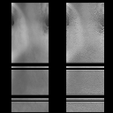
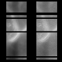
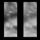
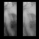
MARS '98 PAYLOADS INTEGRATED AS SCIENTISTS VIEW FIRST CLOSE-UPS OF STRANGE, LAYERED POLAR TERRAINSwirling bands of eroded, layered rock, reminiscent of the edges of Alaskan ice sheets, and an array of light and dark mottled patterns blanket the frigid floor of Mars' south pole, where NASA's newly named Mars Polar Lander will touch down in late 1999.
The new images of the landing zone for the Mars Polar Lander, taken by the camera aboard NASA's Mars Global Surveyor, confirm that this strange, layered terrain in the south polar region represents a dramatic departure from the now-familiar Martian landscapes observed by the Viking landers and Mars Pathfinder. In December 1999, the next lander in a steady series begun by Pathfinder will set down in this uncharted territory to dig for traces of frozen, subsurface water.
"Despite ground fog that obscures part of the surface in these images, we can see much more surface detail than we've ever seen before, which suggests that the 75-degree south latitude landing zone is quite a bit more rugged and geologically diverse than we had previously thought," said Dr. Michael Malin of Malin Space Science Systems, Inc., San Diego, CA. Malin is principal investigator of the Global Surveyor camera and the cameras on the 1998 missions, the Mars Polar Lander and its newly named partner, the Mars Climate Orbiter. In the current images from Mars Global Surveyor, obtained during an aerobraking orbit from about 2,800 kilometers (1,700 miles) above the planet's surface, objects about 15 meters (48 feet) across can be resolved. Once the spacecraft reaches its final mapping orbit early next year, at an average of 378 kilometers (234 miles) above the surface, the camera will be able to resolve ground features as small as 2 to 3 meters (7 to 9 feet) across. This greater clarity will enable views of objects as small as boulders or as subtle as sand dunes. Over the next year, the Global Surveyor images will be used in concert with other spacecraft data such as that obtained by the thermal emission spectrometer to better characterize the geology of the Martian south pole. After Global Surveyor has reached its mapping orbit, data from the spacecraft's laser altimeter, which measures the height and roughness of Martian surface features, will be combined with imaging data to aid the final choice of landing sites. "We have a wonderful opportunity in the next year to study this region with data from Mars Global Surveyor, which underscores the true advantage of conducting a continuing program of Mars exploration," said Dr. John McNamee, Mars Surveyor '98 project manager at NASA's Jet Propulsion Laboratory (JPL), Pasadena, CA. "We will be able to characterize the geology of the whole region and find the best spot to land, one that presents a balance between lander safety and scientific interest. This process does not have to be finalized until June 1999, five months after the lander has been launched and six months before it lands." The landing site images are available on the Internet at JPL's Mars News web site: http://www.jpl.nasa.gov/marsnews/
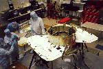
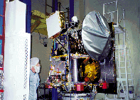
The images are being studied while the 1998 Mars Climate Orbiter and Mars Polar Lander are undergoing key hardware integration and testing at Lockheed Martin Astronautics, Denver, CO. The spacecraft are currently being prepared for transfer to the Lockheed Martin environmental test chambers to ensure that they can survive and operate in the extreme conditions at Mars. At the completion of this testing, the spacecraft will be flown separately to NASA's Kennedy Space Center, FL, for integration with their launch vehicles.
The 1998 Mars lander and orbiter missions are designed to learn more about the history of Mars' climate and the behavior of related Martian volatiles, such as water vapor and ground ice. The orbiter, scheduled for launch on Dec. 10, will conduct a two- year primary mission to profile the Martian atmosphere and map its surface. The lander, scheduled for liftoff on Jan. 3, 1999, will carry out a three-month mission to search for traces of subsurface water in this frozen, layered terrain and any evidence of a physical record of climate change.
To meet these scientific objectives, the orbiter will carry a rebuilt version of the Pressure Modulated Infrared Radiometer (PMIRR) that was lost with Mars Observer in 1993. This atmospheric sounder will observe the global distribution and time variation of temperature, dust, water vapor and condensates in the Martian atmosphere. PMIRR is a collaboration between JPL, Oxford University and Russia's Space Research Institute. Like Mars Global Surveyor, the Mars Climate Orbiter carries a dual camera system, but this one is contained in an amazingly compact package about the size of a pair of binoculars. The Mars color imager's 0.5-kilogram (1 pound) wide-angle camera will return daily low-resolution global views of the planet's atmosphere and surface, while its medium-angle camera will provide higher resolution (40 meters or 30 feet per pixel) images. The medium-angle camera will build global and regional maps of Mars in multiple colors over the course of the mission. These maps will be used to characterize surface properties and changes in the distribution of dust. The 1998 lander carries three scientific packages: the Mars descent imager, again provided by Malin, which will view the landing site at increasingly higher resolution as the lander descends to the surface of Mars; the atmospheric lidar experiment, provided by the Russia space institute, which will monitor the presence and height of atmospheric hazes, coupled with a miniature microphone furnished by The Planetary Society, Pasadena, CA, to record the sounds of Mars; and the Mars Volatile and Climate Surveyor (MVACS) package, led by principal investigator Dr. David Paige of the University of California, Los Angeles. MVACS includes a surface stereo imager based on the Mars Pathfinder camera, both built at the University of Arizona; a meteorology package, built at JPL; a robotic arm, also built at JPL, to acquire soil samples and close-up images of the surface and subsurface; and the thermal and evolved gas analysis experiment, built at the University of Arizona. JPL will oversee mission operations with the spacecraft team at Lockheed Martin Astronautics and the instrument teams located at their home institutions during the lander and orbiter missions. "MVACS and the other science experiments are tailor-made for the exploration of Mars' south pole," said Dr. Richard Zurek, project scientist at JPL. "The robotic arm, which is reminiscent of the Viking arm and scoop that were used to carry out biology experiments in the mid-1970s, is, in fact, much more versatile. It can reach farther out, dig up to 1 meter (3 feet) below the surface and then place soil samples in a miniature oven, called the evolved gas analysis experiment, where the samples are 'cooked' and analyzed for chemical and gas content." Piggybacking on the Mars Polar Lander are two small, 2- kilogram (4.5-pound) microprobes, provided by NASA's New Millennium validation program. Deployed before landing, they will penetrate and embed themselves beneath the Martian surface to study subsurface materials. A microchip with the electronic signatures of students from all over the world will also be flown on the lander. Signatures may be submitted via the Internet to: http://comet.hq.nasa.gov/mars98/ The Mars Polar Lander and Mars Climate Orbiter are the second set of launches in a long-term NASA program of Mars exploration known as the Mars Surveyor Program. The missions are managed by JPL, Pasadena, CA, for NASA's Office of Space Science, Washington, DC. Lockheed Martin Astronautics, Denver, CO, is NASA's industrial partner in the mission. |
| Home | Mars Polar Lander | Deep Space 2 Microprobes | Mars Climate Orbiter |
| Welcome | Mailing List | Links | Credits |
For questions or comments on this website please refer to our list of contacts.
