Mars Polar Lander Timeline
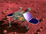 Dec 3, 1999: First Day on Surface. The lander will touch down at 12:14 PM Pacific
Standard Time. On Mars, the local time will be 4 AM. The lander will
unfold its solar panels two minutes after landing and begin pointing
its medium-gain radio antenna at Earth five minutes after landing; the MVACS Meteorology mast will be deployed a short time later. The lander will
establish an Earth-to-Mars radio link approximately 20
minutes after landing. During its first 20-minute communication session,
it will transmit critical information on the spacecraft's health, and possibly some meteorological data and compressed images.
Dec 3, 1999: First Day on Surface. The lander will touch down at 12:14 PM Pacific
Standard Time. On Mars, the local time will be 4 AM. The lander will
unfold its solar panels two minutes after landing and begin pointing
its medium-gain radio antenna at Earth five minutes after landing; the MVACS Meteorology mast will be deployed a short time later. The lander will
establish an Earth-to-Mars radio link approximately 20
minutes after landing. During its first 20-minute communication session,
it will transmit critical information on the spacecraft's health, and possibly some meteorological data and compressed images.
 Dec 3, 1999: SSI Camera Scans Horizon. During the lander's first day on the
surface, it will begin relaying the MARDI descent images back to Earth
and begin surveying its new environment. Some of the most anticipated
data that will be acquired during the first days of the mission will
be a scan of the horizon by the MVACS Surface Stereo Imager (SSI).
The SSI is nearly identical to the IMP camera that flew on Mars Pathfinder,
and will be capable of providing stereo color panoramas of the landing
site. Additionally, the SSI will acquire quantitative data relating to clouds
and water vapor in the Martian atmosphere.
Dec 3, 1999: SSI Camera Scans Horizon. During the lander's first day on the
surface, it will begin relaying the MARDI descent images back to Earth
and begin surveying its new environment. Some of the most anticipated
data that will be acquired during the first days of the mission will
be a scan of the horizon by the MVACS Surface Stereo Imager (SSI).
The SSI is nearly identical to the IMP camera that flew on Mars Pathfinder,
and will be capable of providing stereo color panoramas of the landing
site. Additionally, the SSI will acquire quantitative data relating to clouds
and water vapor in the Martian atmosphere.
 Dec 3, 1999 - Mar 1, 2000: Daily and Seasonal Atmsopheric Variations. During its three month surface
mission, the lander's instruments will measure both daily and
seasonal variations in atmospheric properties. The LIDAR instrument
will make the first measurements of the Martian atmosphere. The MVACS
Meterology Package's Tunable Diode Laser (TDL) Spectrometer will make the
first accurate in situ measurements of the concentration of water vapor in the Martian atmosphere. The MVACS MET sensors will make the first measurements
of temperature, pressure and winds in the Martian southern hemisphere.
Dec 3, 1999 - Mar 1, 2000: Daily and Seasonal Atmsopheric Variations. During its three month surface
mission, the lander's instruments will measure both daily and
seasonal variations in atmospheric properties. The LIDAR instrument
will make the first measurements of the Martian atmosphere. The MVACS
Meterology Package's Tunable Diode Laser (TDL) Spectrometer will make the
first accurate in situ measurements of the concentration of water vapor in the Martian atmosphere. The MVACS MET sensors will make the first measurements
of temperature, pressure and winds in the Martian southern hemisphere.
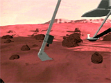 Dec 4, 1999 - Mar 1, 2000: Soil Sample Acquired by Robotic Arm. During the third day of
the mission, the MVACS Robotic Arm will acquire its first samples of
Martian soil. The robotic arm is about two meters long and
has approximately the same strength as a human arm. The arm
includes a probe to measure the temperature of surface
and subsurface soil, and a Robotic Arm Camera which can take close-up
images of the arm's workspace and soil samples.
Dec 4, 1999 - Mar 1, 2000: Soil Sample Acquired by Robotic Arm. During the third day of
the mission, the MVACS Robotic Arm will acquire its first samples of
Martian soil. The robotic arm is about two meters long and
has approximately the same strength as a human arm. The arm
includes a probe to measure the temperature of surface
and subsurface soil, and a Robotic Arm Camera which can take close-up
images of the arm's workspace and soil samples.
 Dec 4, 1999 - Mar 1, 2000: Soil Delivered to TEGA for Analysis. The Robotic Arm will deliver soil samples to the MVACS Thermal And Evolved
Gas Analyzer (TEGA) for analysis. The TEGA sifts the soil into
one of eight small ovens. As the samples are heated, the quantities of
water vapor and carbon dioxide are measured. TEGA data can be used to determine the concentrations of of water ice,
adsorbed water and carbon dioxide, hydrated minerals and carbonates
in the soil. These measurements will enhance our understanding of the distribution and behavior of volatiles
on Mars, and will give clues to Mars' climate history.
Dec 4, 1999 - Mar 1, 2000: Soil Delivered to TEGA for Analysis. The Robotic Arm will deliver soil samples to the MVACS Thermal And Evolved
Gas Analyzer (TEGA) for analysis. The TEGA sifts the soil into
one of eight small ovens. As the samples are heated, the quantities of
water vapor and carbon dioxide are measured. TEGA data can be used to determine the concentrations of of water ice,
adsorbed water and carbon dioxide, hydrated minerals and carbonates
in the soil. These measurements will enhance our understanding of the distribution and behavior of volatiles
on Mars, and will give clues to Mars' climate history.
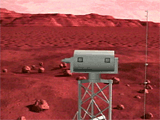
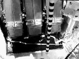 Dec 4, 1999 - Mar 1, 2000: Robotic Arm Camera Image. The MVACS Robotic Arm Camera (RAC) will provide
images of the Martian surface and the Mars Polar Lander from a unique
perspective. At it's closest focus, the RAC can obtain images with a
resolution of 23 microns per pixel, which is higher resolution than
the unaided human eye. The image on the left, acquired during lander testing
at Lockheed Martin, is a RAC image of the lander deck
showing the TEGA and the Robotic Arm
Temperature Probe.
Dec 4, 1999 - Mar 1, 2000: Robotic Arm Camera Image. The MVACS Robotic Arm Camera (RAC) will provide
images of the Martian surface and the Mars Polar Lander from a unique
perspective. At it's closest focus, the RAC can obtain images with a
resolution of 23 microns per pixel, which is higher resolution than
the unaided human eye. The image on the left, acquired during lander testing
at Lockheed Martin, is a RAC image of the lander deck
showing the TEGA and the Robotic Arm
Temperature Probe.
 Dec 4, 1999 - Mar 1, 2000: The Sounds of Mars. The Mars Microphone will make the first recordings
of the sounds of Mars. The microphone will be capable of detecting sounds
generated by the lander and its instruments, as well as natural sound in the
Martian environment. Microphone data will typically be acquired for 15 seconds each day, with the possibility of longer listening periods to search
for unusual or intermittant sounds.
Dec 4, 1999 - Mar 1, 2000: The Sounds of Mars. The Mars Microphone will make the first recordings
of the sounds of Mars. The microphone will be capable of detecting sounds
generated by the lander and its instruments, as well as natural sound in the
Martian environment. Microphone data will typically be acquired for 15 seconds each day, with the possibility of longer listening periods to search
for unusual or intermittant sounds.
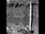 Dec 4, 1999 - Mar 1, 2000: Digging for ice. One of the major goals of the MVACS investigation
is to search for Martian ground ice. Subsurface ice is common at high-latitudes
on Earth. The image at left shows a near-surface ice layer exposed in
the dry valleys of Antarctica. Models for the behavior of water
on Mars predict that ice could be stable throughout the year as
as close as 20 cm below the surface at the Mars Polar
Lander's landing latitude. During the course of the mission, MVACS robotic arm will scoop up soil and dig a trench up to 50 cm deep. The trench walls
will be examined by the Robotic Arm Camera and samples from inside the
trench will be analyzed for water ice content by the MVACS TEGA. The discovery
of ground ice would be important for Mars science, as well for future human exploration
of Mars.
Dec 4, 1999 - Mar 1, 2000: Digging for ice. One of the major goals of the MVACS investigation
is to search for Martian ground ice. Subsurface ice is common at high-latitudes
on Earth. The image at left shows a near-surface ice layer exposed in
the dry valleys of Antarctica. Models for the behavior of water
on Mars predict that ice could be stable throughout the year as
as close as 20 cm below the surface at the Mars Polar
Lander's landing latitude. During the course of the mission, MVACS robotic arm will scoop up soil and dig a trench up to 50 cm deep. The trench walls
will be examined by the Robotic Arm Camera and samples from inside the
trench will be analyzed for water ice content by the MVACS TEGA. The discovery
of ground ice would be important for Mars science, as well for future human exploration
of Mars.
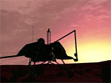 Mar 1, 2000: Mars Sunset. The longevity of the Mars Polar Lander will be limited
by its ability to withstand the rigors of the changing polar environment.
The lander will arrive during the late Martian spring season in the southern
hemisphere, when the sun will be above the horizon throughout the day, and
surface temperatures will vary between -80 °C and -20 °C. Towards the end of
the summer season, the sun will dip closer and closer to the horizon,
making it colder, and more difficult for the lander to generate
solar power. March 1, 2000, will mark the first true sunset at the Mars
Polar Lander landing site. It is not expected that the lander will be
able to collect much useful scientific data after this point.
After it dies, the lander will spend the next year frozen in the Martian
south seasonal carbon dioxide polar cap at a temperature of -125 °C. There
is a faint possibility that the lander will revive itself when the
spring sun returns in 2001.
Mar 1, 2000: Mars Sunset. The longevity of the Mars Polar Lander will be limited
by its ability to withstand the rigors of the changing polar environment.
The lander will arrive during the late Martian spring season in the southern
hemisphere, when the sun will be above the horizon throughout the day, and
surface temperatures will vary between -80 °C and -20 °C. Towards the end of
the summer season, the sun will dip closer and closer to the horizon,
making it colder, and more difficult for the lander to generate
solar power. March 1, 2000, will mark the first true sunset at the Mars
Polar Lander landing site. It is not expected that the lander will be
able to collect much useful scientific data after this point.
After it dies, the lander will spend the next year frozen in the Martian
south seasonal carbon dioxide polar cap at a temperature of -125 °C. There
is a faint possibility that the lander will revive itself when the
spring sun returns in 2001.
 Mar 1, 2000 - Sep 30, 2000: Observations Compared with Physical Models. The data acquired
by the Mars Polar Lander instruments will provide a clear picture of the
local environment at the landing site. The knowledge gained at the
landing site can be generalized to the planet as a whole, and to oher
climatic regimes by assimilating the Mars Polar Lander datasets
into physical models. Specific scientific questions that can be
addressed will include: What is the global distribution of ground ice
on Mars? How much water and carbon dioxide are trapped in the Martian
soil? How much water exchanges between the Martian atmsosphere and
surface? How has the distribution and behavior
of water and carbon dioxide on Mars varied over time?
Mar 1, 2000 - Sep 30, 2000: Observations Compared with Physical Models. The data acquired
by the Mars Polar Lander instruments will provide a clear picture of the
local environment at the landing site. The knowledge gained at the
landing site can be generalized to the planet as a whole, and to oher
climatic regimes by assimilating the Mars Polar Lander datasets
into physical models. Specific scientific questions that can be
addressed will include: What is the global distribution of ground ice
on Mars? How much water and carbon dioxide are trapped in the Martian
soil? How much water exchanges between the Martian atmsosphere and
surface? How has the distribution and behavior
of water and carbon dioxide on Mars varied over time?
 Mar 1, 2000 - Sep 30, 2000: Results Published. In addition to the rapid release of images
and other scientific results through the web and press conferences,
the Mars Polar Lander science teams will publish the results of their
investigations in peer-reviewed scientific journals.
Mar 1, 2000 - Sep 30, 2000: Results Published. In addition to the rapid release of images
and other scientific results through the web and press conferences,
the Mars Polar Lander science teams will publish the results of their
investigations in peer-reviewed scientific journals.
 Sep 30, 2000: Data Archived. In addition to publication, a complete record
of all the data acquired by the Mars Polar Lander instuments will be
archived by NASA's Planetary Data System (PDS). The PDS archive will
enable scientists from future generations to analyze and compare the
Mars Polar Lander data with that obtained by all past planetary missions.
Sep 30, 2000: Data Archived. In addition to publication, a complete record
of all the data acquired by the Mars Polar Lander instuments will be
archived by NASA's Planetary Data System (PDS). The PDS archive will
enable scientists from future generations to analyze and compare the
Mars Polar Lander data with that obtained by all past planetary missions.
|