


|
|
Landing Site: Science and Engineering Guidelines
Science Guidelines
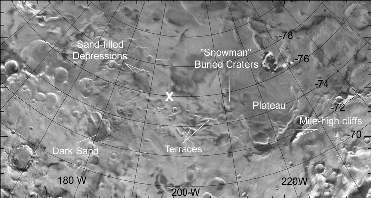
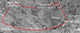
The most extensive data that the Team used to choose
a landing site are images of the south polar region from the Viking
and Mariner 9 spacecraft. Because they are low-magnification images
taken from orbit, they were used mostly to rule out unsuitable regions.
For example, areas with large
obstacles (cliffs, craters, etc.) or areas with unexplained
colorations were ruled out. Very recent data from the Mars Orbiter
Laser Altimeter (MOLA) and the Mars Orbiter Camera (MOC) were very
valuable in understanding the slopes and textures of different
areas. These instruments are aboard the Mars Global Surveyor spacecraft,
currently at Mars.
A major science goal is that the lander land on the Polar Layered
Deposits, a geologic unit that contains fine-scale layering that may be
a record of climate change. Accordingly, places where the layered material
is absent, such as surfaces consisting of older, underlying terrain or
slope debris, were ruled out.
Engineering Guidelines
 Trajectory. Trajectory.
Where is the spacecraft capable of going?
One limitation is that the landing site location must allow the spacecraft
to enter the atmosphere at a suitable angle. If the spacecraft enters the
atmosphere too quickly, to much frictional heat will be generated and
it will burn up.
If the trajectory is too shallow, the spacecraft
will skip out of the atmopsphere and miss the surface. Accordingly,
the landing site was limited to regions equatorward of 78 degrees south.
Because Mars rotates on
its axis relatively fast (24.6 hours), any longitude on Mars can be
reached by timing the spacecraft's arrival.
Safety.
Where is the spacecraft capable of landing and
surviving?
The Mars Surveyor Operations Project (MSOP) at the Jet
Propulsion Laboratory identified the following safety constraints that guided the selection of the landing site:
- Elevation - must be < 6000 m above "sea level" on Mars (6 mb atmospheric pressure)
- Slopes - must be < 10 degrees
- Rocks - rock coverage < 15% of surface; spacecraft clearance is 35 cm
- Topography - away from hills, craters, cliffs
- Temperature - above the frost point of water and carbon dioxide
Click to Enlarge
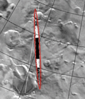 Targeting. Targeting.
Where will the spacecraft actually end up?
The spacecraft's trajectory and time of arrival will be changed by
firing on-board thrusters during the journey to Mars. The
primary maneuver was on September 1, with further adjustments being made
as the spacecraft reaches Mars. The accuracy in these maneuvers
results in a spread of possible landing sites around the aim point,
called an error ellipse (about 10 km by 200 km, see right). In
practical terms, this means
that the landing site can be chosen within a particular valley or between
two craters (above), but not next to a particular rock.
|