|
Update of the Mars Polar Lander Landing Site
High-Resolution TIFF (~3MB)
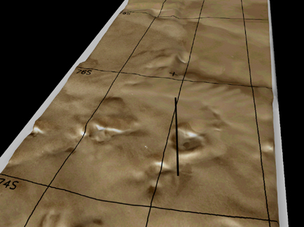
CAPTION:
Perspective view of the preliminary locations of the Mars Polar Lander
and Deep Space 2 Microprobes. The Polar Lander site, marked by a
cross near the center of this Viking Orbiter image mosaic, is
situated near the mouth of a shallow valley. Regional surface slopes
are less than 2 degrees from horizontal. The Microprobes are thought
to have reached the surface along a line which crosses through an impact
crater 25 kilometers in diameter. Surface slopes within the crater are
less than 5 degress while the crater walls have steeper slopes. True
surface slopes are much less steep than they appear because the relative
heights of surface features have been exaggerated by a factor of 30.
This three-dimension view of the surface was created using topographic
data from the Mars Orbiter Laser Altimeter aboard the Mars Global
Surveyor
spacecraft and rendered by the NASA Ames Research Center Virtual Reality
Team. Grid lines are marked every 2 degrees latitude and at longitudes
192, 196, and 200W. South is toward the top of the image.
|