
MPL MARDI Release No. MARDI99-01, 1 December 1999

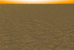
On the left is a preview of what the polar landing site might look like from a few hundred meters (several football fields) altitude above the surface. This computer-generated view looks across the polar layered terrain and towards the horizon. It was generated using pictures taken over the past several months by the Mars Global Surveyor (MGS) Mars Orbiter Camera (MOC). The landing site topography was determined by using a shape-from-shading (photoclinometry) computer program to examine a MOC image of a uniformly-frost covered section of Mars Polar Lander's landing site. That same image was then used in the computer to provide additional surface detail. This view looks south-southeast across an area of ridged and rugged terrain within Mars Polar Lander's landing ellipse. The horizon is about 10 km (6 miles) away. The illumination was chosen to approximate what will be seen during the Polar Lander's descent on Friday. Real pictures from the Mars Descent Imager are scheduled to be returned over the weekend (December 3-6, 1999).
Image Credits:
| Home | Mars Polar Lander | Deep Space 2 Microprobes | Mars Climate Orbiter |
| Welcome | Mailing List | Links | Credits |
For questions or comments on this website please refer to our list of contacts.