
G. E. Cunningham
3/31/98
The Mars Global Surveyor spacecraft has resumed observations of the surface of Mars. An early objective is to attempt to photograph the Mars Pathfinder landing site, features in the Cydonia region, and the Viking lander sites. This announcement fulfills NASA’s commitment to announce to the public when these opportunities will occur and when the resulting pictures will be released.
At the launch of the Mars Global Surveyor mission, NASA announced that it would re-photograph the Cydonia region of Mars -- an area that contains a number of features including the famous "Face on Mars" -- when Surveyor was over that region during its mapping period.
The initial announcement (26-MAR-98 JPL Press Release) that Surveyor would have a opportunity to photograph these areas was made on March 26, 1998, the day that Surveyor completed its first phase of aerobraking. The opportunity to accelerate the schedule of photographing these areas significantly before the mapping period has been afforded by the recent modification of Surveyor’s mission. This modification was made to extend aerobraking for a year in order to compensate for a structural weakness discovered in one of Surveyor’s solar panels.
Targeted image acquisition schedule
The opportunities to see these targets from the Surveyor spacecraft will
occur in three clusters of two and a half days each during the next month.
Each target will be visible once in each cluster and the clusters will be
separated by nine days. (We had originally predicted a separation of eight
days, but the parameters of the orbit as established yielded a repeat period
of nine days.)
After several orbits of Mars by Surveyor in its new, non-aerobraking orbit, flight controllers have now been able to predict when the opportunities will occur, and have made an estimate of the approximate time when the resulting images will be posted on the web sites identified below.
| Date Time (UTC/Pacific) | Orbit | Target Number | Approximate Internet Posting |
| 4-3-98 09:58/ 1:58 a.m. | 216 | Viking Lander 1 | April 6 |
| 4-3-98 21:37/ 1:37 p.m. | 217 | Viking Lander 2 | April 7 |
| 4-4-98 09:16/ 1:16 a.m. | 218 | Mars Pathfinder | April 7 |
| 4-5-98 08:33/ 12:33 a.m. | 220 | Cydonia | April 6 (mid-a.m.) |
| Date Time (UTC/Pacific) | Orbit | Target Number | Approximate Internet Posting |
| 4-12-98 15:23/ 8:23 a.m. | 235 | Viking Lander 1 | April 14 |
| 4-13-98 03:01/ 8:01 p.m. | 236 | Viking Lander 2 | April 15 |
| 4-13-98 14:40/ 7:40 a.m. | 237 | Mars Pathfinder | April 15 |
| 4-14-98 13:57/ 6:57 a.m. | 239 | Cydonia | April 14 (mid-p.m.) |
| Date Time (UTC/Pacific) | Orbit | Target Number | Approximate Internet Posting |
| 4-21-98 20:45/ 1:45 p.m. | 254 | Viking Lander 1 | April 23 |
| 4-22-98 08:23/ 1:23 a.m. | 255 | Viking Lander 2 | April 24 |
| 4-22-98 20:02/ 1:02 p.m. | 256 | Mars Pathfinder | April 24 |
| 4-23-98 19:18/ 12:18 p.m. | 258 | Cydonia | April 24 (mid-a.m.) |
After this period
At the end of April, Surveyor will begin a month long period in which communications
with the spacecraft will be degraded as Surveyor moves behind the Sun in
what is termed Solar Conjunction. During the month of May, Surveyor will
be put into a special sun pointed attitude to keep its science instruments
warm. For two out of every eight hours, it will rotate to point its high
gain antenna to Earth to provide engineering telemetry on the spacecraft’s
health, and to allow X and Ka-Band radio wave propagation experiments. At
the end of May, Surveyor will return to the acquisition of science data.
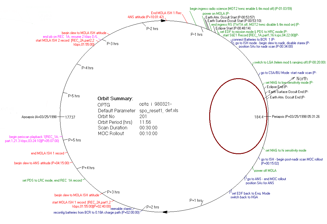
Sequence of events during the targeted imaging acquisition period
Surveyor executes a standard sequence of events during each revolution around
Mars. The diagram below depicts the relative timing of these events. Remember
that the spacecraft moves very rapid when it is near to Mars and much slower
when it is far away. The parameters, such as orbital velocity and distance
to the planet can be observed in real time by looking at the Real
Time Orbit Update elsewhere on this web site. A graphical representation
of Surveyor’s sequence of events, called the SFOS,
Space Flight Operations Schedule, can also be seen elsewhere on this
web site.
All of the selected targets are located south of the Surveyor’s periapsis, or point of closest approach to the Martian surface. Shortly before the spacecraft reaches this point, Surveyor will rotate slightly so that when it nears the selected target, the camera’s field of view will sweep across the target as the spacecraft flies south and rises away from its closest approach. After the spacecraft attitude has stabilized, the camera will begin acquiring the image data, line by line, in the same manner as a FAX machine reads a sheet of paper. The spacecraft’s motion provides the motion that is analogous to the sheet moving through the FAX machine. The resulting image will be a long, narrow strip laid across the target. The parameters used to control the camera’s operation will be optimized to maximize the probability that the target will be within the camera’s field of view and at the same time assure the best resolution.
Image return time line
As the image is acquired, it is stored in a large solid state buffer memory
in the camera. Since the data is acquired much faster than it can be transmitted
to Earth, there are three stages of buffering to reduce the date transmission
rate. The image data is first stored in the camera’ buffer memory.
Then the data is readout of the camera’s buffer at a rate lower than
the acquisition rate to the spacecraft’s solid state recorder. When
the spacecraft’s high gain antenna is point toward Earth, the data
is readout out the solid state recorder and transmitted to Earth at an even
slower rate of 21 kilobits per second.
Playback of the solid state recorder begins about 7 hours after the images are acquired. Playback is complete about 3 hours later.
It currently takes the radio signal 20 minutes to travel from the spacecraft to Earth.
The data is received at one of NASA’s Deep Space Tracking Stations at Goldstone, California, near Madrid, Spain or near Canberra, Australia, and is sent by satellite to JPL in Pasadena, California. There the image data, along with all rest of Surveyor’s science and engineering data is placed in the Project Data Base. This process takes only seconds for each bit of data. Thus the image data will be complete in the Project Data Base about 10 and a half hours after it is acquired.
If the data arrives in the Project Data Base on the graveyard shift when the camera operators don’t work, it will not be fetched until about 9 AM Pacific time the next morning.
When image data is fetched from the data base by the camera operators, it is assembled into a "raw" image. The "raw" image may contain data errors and data drop outs introduced by noise in the telecommunications channel between the spacecraft and the ground. This process takes about 30 minutes.
The image of the Cydonia region will posted on this web site in a "raw" form in about another hour. A caption that includes the image identification number, the acquisition time, the predicted center latitude and longitude (the target location) and the local solar time, will accompany the image. No interpretation will be offered of what the image appears to contain.
Further contrast enhancement and noise removal will be performed by JPL’s Multi-mission Image Processing Laboratory. A "cleaner" version of the image will then be posted on this web site within a few hours.
The images of the Viking and Mars Pathfinder landing sites will not be released in their "raw" form, but will under go further enhancement and analysis to try to pin point the vehicles because they are so small and at the limits of the camera’s resolution. This process will take another 24 hours or so. After that time, the images with a comprehensive description of what the images contain, will be posted on this web site.
Where to get the images
All the images as posted will be available simultaneously on the following
web sites:
http://mars.jpl.nasa.gov (This site is mirrored to 30 sites world wide.)
http://www.jpl.nasa.gov/marsnews
http://photojournal.jpl.nasa.gov