![]()
![]()
![]()
![]()
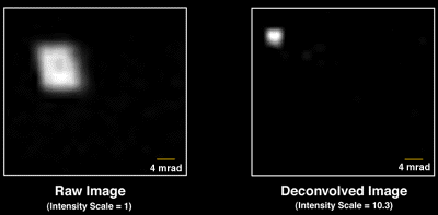 |
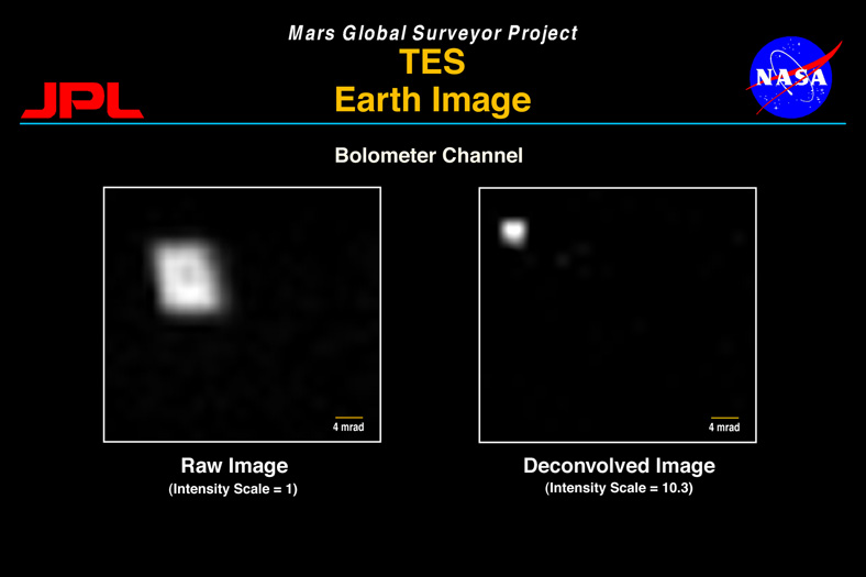
Several weeks after launch, all of the science instruments aboard the Mars Global Surveyor spacecraft were activated and pointed at the Earth. Over a several-day period, the instruments used the Earth as a target in order to generate data for calibration purposes.
This image of the Earth was assembled from bolometer channel data collected by the Thermal Emission Spectrometer (TES) on 24 November 1996. At the time the data was gathered, Surveyor was at a distance of 4.8 million kilometers from Earth. The TES bolometer channel is sensitive to infrared wavelengths from 4.5 microns to 100 microns with a field of view (FOV) response of approximately 8.3 mrad.
The raw image on the left was assembled from successive raster scans by the TES pointing mirror. The scans were done in 25 steps (top to bottom) a with 1.6 mrad step size and a 4 second per step duration. The spacecraft rolled slowly in the orthogonal axis (left to right) at 1.6 mrad/s, simultaneous with the mirror scans. The raw image of the Earth exhibits the expect FOV response of the TES (about 8.3 mrad) with the characteristic dimple, or hole, in the center due to the physical construction of the bolometer detector.
The image on the right is a deconvolved, or corrected, image of the Earth using the data from the left image. With detail knowledge of the TES FOV response from laboratory calibration data and extensive computer process, a deconvolved image was constructed with the FOV effects of the TES removed. The image clearly exhibits the resolved Earth which is expected to be 2.7 mrad in diameter.
The deconvolution was performed by John Callas with algorithms developed at the Jet Propulsion Laboratory. The TES instrument is operated by the Arizona State University under the direction of Dr. Phil Christensen.