
Click on image for full resolution version
Mars Global Surveyor Orbiter Camera Release Number        MOC2-1
Mars Global Surveyor Orbiter Camera Image ID        552348805.20
Caption
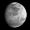
This image is the first view of Mars taken by the Mars Global Surveyor
Orbiter Camera (MOC). It was acquired the afternoon of 2 July 1997
when the MGS spacecraft was 17.2 million kilometers (10.7 million
miles) and 72 days from encounter. At this distance, the MOC's
resolution is about 64 km per picture element, and the 6800 km (4200
mile) diameter planet is 105 pixels across. The observation was
designed to show the Mars Pathfinder landing site at 19.4° N,
33.1° W approximately 48 hours prior to landing. The image shows
the north polar cap of Mars at the top of the image, the dark feature
Acidalia Planitia in the center with the brighter Chryse plain
immediately beneath it, and the highland areas along the Martian
equator including the canyons of the Valles Marineris (which are
bright in this image owing to atmospheric dust). The dark features
Terra Meridiani and Terra Sabaea can be seen at the 4 o`clock
position, and the south polar hood (atmospheric fog and hazes) can be
seen at the bottom of the image. Launched on November 7, 1996, Mars
Global Surveyor will enter Mars orbit on Thursday, September 11
shortly after 6:00 PM PDT. After Mars Orbit Insertion, the spacecraft
will use atmospheric drag to reduce the size of its orbit, achieving a
circular orbit only 400 km (248 mi) above the surface in early March
1998, when mapping operations will begin.
The Mars Global Surveyor is operated by the Mars Surveyor Operations
Project managed for NASA by the Jet Propulsion Laboratory, Pasadena
CA. The Mars Orbiter Camera is a duplicate of one of the 6
instruments originally developed for the Mars Observer mission. It was
built and is operated under contract to JPL by an industry/university
team led by Malin Space Science Systems, San Diego, CA.


