
Mars Global Surveyor Mars Orbiter Camera Release:          MOC2-33A, -33B, -33C
Mars Global Surveyor Mars Orbiter Camera Image ID:         569840297.10004
                                                           P100-04
|
Click Here for more information on MGS data release and archiving plans. |
CAPTION
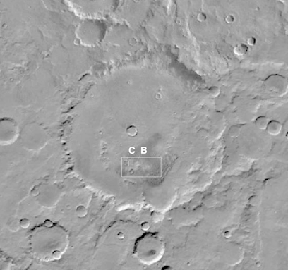
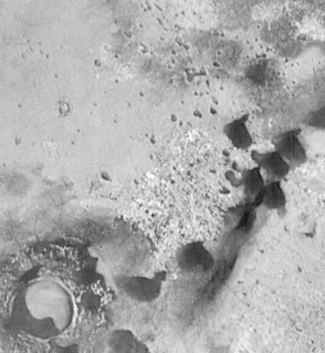
Kaiser Crater is one of several impact basins in the Hellespontus region of Mars that contain large dune fields of dark sand. The dune fields were first recognized in images taken by Mariner 9 in 1972. Hellespontus is one of the main regions where dust storms have been seen to originate over the past 200 years. Winds have also acted to trap massive quantities of dark sand on the broad crater floors of the region. The best pre-Mars Global Surveyor images of the Kaiser Crater dunes came from the Viking 1 and 2 Orbiters in the late 1970s (See Context Frames (A) and (B)).The MOC subframe, taken during the 100th orbit of Mars Global Surveyor on January 21, 1998, is centered at 47.1°S latitude, 341.3°W longitude and shows a close-up of some of the smaller, isolated dunes that occur west of the main dune field. The dune just below the center of the frame covers an area about 680 meters by 480 meters (0.4 x 0.3 miles) in size. The circular feature in the lower left corner is a small crater that formed by meteor impact some time before the dunes were present in this area. This "small" crater has a diameter of 1.2 kilometers (0.75 miles)--- the same diameter as the famous "Meteor Crater" of northern Arizona, U.S.A., on Earth.
It is unknown whether the dunes in Kaiser Crater are presently active. Active dunes would be those in which sand moves when the wind blows under present-day conditions. The processes by which sand moves in a dune are called saltation and traction "Saltation" refers to the short hops that sand grains can make when the wind picks them up and blows them across the surface. "Traction" refers to those grains that roll along the ground because they are too heavy for the wind to pick up. The fact that these dunes do not have a coating of fine, bright dust on them suggests that they could be active--that is, sand grains (approximately 63 to 2000 micrometers in size) can move when the wind blows and cause finer-grained material ("dust") to be removed from the dune surface.
The larger dunes in Kaiser Crater (see context images (A) and (B)) appear to have most recently been traveling from east to west (left to right). Examination of the dunes in the MOC subframe, however, suggests that it is unclear which direction these particular, smaller dunes are traveling because they do not show the characteristic 33°-steep slip-faces which occur on the down-wind sides of typical sand dunes. It is also unclear whether these dunes have moved since the Viking high-resolution context frame (B) image was obtained in 1978 (10 Mars years ago), as there has been no perceptible change in the dunes' position or shape down to the limits of the resolution of the Viking (49 m/pixel, vs. MOC (10 m/pixel) images.
Context frame (B; Viking Orbiter 2 #575B60) is the highest-resolution image obtained of this dune field prior to the Mars Global Surveyor mission. At a resolution of 49 meters/pixel, it is about 5 times lower resolution than the MOC image.
The MOC subframe of #10004 was featured as Figure 3b in Malin et al., "Early Views of the Martian Surface from the Mars Orbiter Camera of Mars Global Surveyor," Science, v. 279, no. 5357, pp. 1681-1685. Note that in the caption for this figure in the Science article, the word "rare" applies to the shape of these dunes, not to the occurrence of dunes in general.
Malin Space Science Systems and the California Institute of Technology built the MOC using spare hardware from the Mars Observer mission. MSSS operates the camera from its facilities in San Diego, CA. The Jet Propulsion Laboratory's Mars Surveyor Operations Project operates the Mars Global Surveyor spacecraft with its industrial partner, Lockheed Martin Astronautics, from facilities in Pasadena, CA and Denver, CO.
Contact: info@msss.com
 To MSSS
Home Page
To MSSS
Home Page