Mars Global Surveyor
Mars Orbiter Camera
MOC Aerobraking Orbit Observations - P003-P007
During the past three weeks, the Mars Global Surveyor Orbiter Camera
(MOC) has acquired about a dozen moderately high resolution images of
Mars to improve our understanding of the exposure and focus control of
the camera, in anticipation of mapping operations that will begin in
March of next year. Most of the images are of relatively poor
quality, as the MGS spacecraft is not yet in the orbit for which the
MOC was designed. Specifically, the illumination conditions are poor
(the surfaces that MOC is imaging are presently only about one-fourth
as bright as they will be during mapping), and the range to the planet
when imaging can occur is between three and five times greater than
the mapping distance. In addition, information to remove instrument
characteristics such as sensitivity variations is just now being
assembled, so many of the images have attributes or artifacts, such as
bright and dark streaks, caused by these characteristics.
However, as the spacecraft has moved from the low illumination
conditions near the evening terminator towards higher sun elevation
angles, the images have been improving. Two of the best images are
presented here in several versions, along with "context" frames
derived from Viking Orbiter images.
|
Note: The MOC images are made available
in order to share with the public the excitement of new
discoveries being made via the Mars Global Surveyor spacecraft.
The images may be reproduced only if the
images are credited to "Malin Space Science Systems/NASA".
Release of an image does not constitute a release of
scientific data. An image and its caption should not be
referenced in the scientific literature. Full data releases
to the scientific community are scheduled by the Mars Global
Surveyor Project and NASA Planetary Data System. Typically, data
will be released after a 6 month calibration and validation period.
Click Here for more information on MGS data release and
archiving plans.
|
Mars Global Surveyor Mars Orbiter Camera Release:       MOC2-11A,-11B,-11C
Mars Global Surveyor Mars Orbiter Camera Image IDs:          559142748.503
                                                                   P005_03
Click on images for full resolution versions
(A) (B)
(B)
A: Viking Orbiter Context Image (250 KB) B: MOC Image P005_03 (593
KB)
(C)
Oblique view of P005_03 (132 KB)
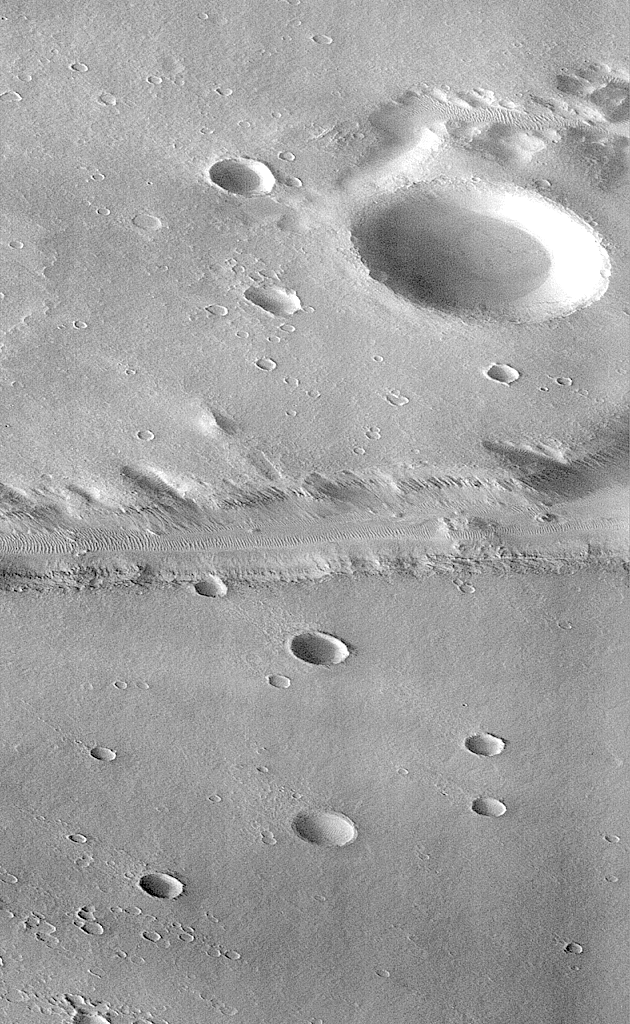
MOC image P005_03 was acquired at 6:25 AM PDT on September 19, 1997,
about 11 minutes after Mars Global Surveyor passed close to the planet
for the fifth time. During the imaging period, the spacecraft was
canted towards the sun-lit hemisphere by 25°, and the MOC was
obliquely viewing features about 1600 km (1000 miles) away. The
resolution at that distance was about 6 meters (20 feet) per picture
element (pixels), but in order to improve the number of gray
levels, the pixels were summed in both the cross-track and along-track
directions, yielding final resolution of about 12 meters (40 feet) per
pixel. The MOC image covers an area about 12 km X 12 km (7.5 X 7.5
miles).
Shown above are three pictures:
(A) is excepted from the U.S. Geological Survey's Mars
Digital Image Mosaic, showing the Labyrinthus Noctis area west of the
Valles Marineris. This image is about 175 km (109 miles) square. The
outline of the MOC high resolution (Narrow Angle ) camera image is
centered at 4.6°S, 102.6°W.
(B) is the MOC frame P005_03. Because the MOC acquires its
images one line at a time, the cant angle towards the sun-lit portion
of the planet, the spacecraft orbital velocity, and the spacecraft
rotational velocity combined to distort the image slightly.
(C) shows P005_03 skewed and rotated to the perspective that
MOC was viewing at the time the image was taken.
Labyrinthus Noctis is near the crest of a large (many thousands of
kilometers) updoming of the Martian crust, and the 2000 meter (6500
foot) deep canyons visible in these pictures are bounded by faults.
Debris shed from the steep slopes has moved down into after the
canyons opened. Small dunes are seen in the lowest area, beneath the
high cliffs.
Mars Global Surveyor Mars Orbiter Camera Release:       MOC2-12A,-12B,-12C
                                                                 -12D,-12E
Mars Global Surveyor Mars Orbiter Camera Image IDs:          559303731.605
                                                                   P006_05
Click on images for full resolution versions
(A) (B)
(B)
(C)
A: Viking Orbiter Context Image (146 KB) B: MOC Image P006_05 (655
KB)
C: MOC P006_5 (enlargement) (794 KB)
(D)
(E)
D:
Oblique view of P006_05 (175 KB)
E: Oblique view of P006_05
(Enlargement)(628 KB)
At 3:08:30 AM on September 21, 1997, the MOC field of view swept
across the highland valley network Nirgal Vallis at
28.5°S, 41.6 W. Although the MGS spacecraft was at an altitude
of about 400 km (250 miles), the MOC was pointed obliquely across the
planet at about 35°, so the distance to Nirgal Vallis was closer
to 800 km (500 miles). At that range and viewing angle, the MOC field
of view was about 16 km (10 miles) wide, and the resolution was about
9 meters (30 feet) per pixel. The acquired image is 36 km (23 miles)
long.
Five images are shown above:
(A) is an excerpt from the USGS MDIM, roughly 180 km (112 mile)
square. The small box outlines the MOC image acquisition.
(B) is MOC frame P006_05, shown here at reduced resolution
because the full image is almost 7 MBytes in size. Because the MOC
acquires its images one line at a time, the cant angle towards the
sun-lit portion of the planet, the spacecraft orbital velocity, and
the spacecraft rotational velocity combined to significantly distort
the image. However, even in this reduced resolution version, dunes
can be seen in the canyon and in areas on the upland surface around
the canyon.
(C) shows a portion of P006_05 at the full resolution of the
data. This view shows the dunes more clearly, and also illustrates
better the distortion introduced by the method of data acquisition.
(D) shows P006_05 skewed and rotated to the perspective that
MOC was viewing at the time the image was taken.
(E) shows a full-resolution version of a portion of the rotated
perspective view.
Nirgal Vallis is one of a number of canyons called valley
networks or runoff channels. Much of the debate concerning
the origin of these valleys centers on whether they were formed by
water flowing across the surface, or by collapse and upslope erosion
associated with groundwater processes. At the resolution of this
image, it is just barely possible to discern an interwoven pattern of
lines on the highland surrounding the valley, but it is not possible
to tell whether this is a pattern of surficial debris (sand or dust),
as might be expected with the amount of crater burial seen, or a
pattern of drainage channels. With 4X better resolution from its
mapping orbit, MOC should easily be able to tell the difference
between these two possibilities.
Launched on November 7, 1996, Mars Global Surveyor entered Mars orbit
on Thursday, September 11, 1997. The spacecraft has been using
atmospheric drag to reduce the size of its orbit for the past three
weeks, and will achieve a circular orbit only 400 km (248 mi) above
the surface early next year. Mapping operations begin in March 1998.
At that time, MOC narrow angle images will be 5-10 times higher
resolution than these pictures.
Malin Space Science Systems and the California Institute of Technology
built the MOC using spare hardware from the Mars Observer mission.
MSSS operates the camera from its facilities in San Diego, CA. The
Jet Propulsion Laboratory's Mars Surveyor Operations Project operates
the Mars Global Surveyor spacecraft with its industrial partner,
Lockheed Martin Astronautics, from facilities in Pasadena, CA and
Denver, CO.
To
MSSS MGS Page
To MSSS Mars
Page
 Return to MSSS Home Page
Contact: info@msss.com
 (B)
(B)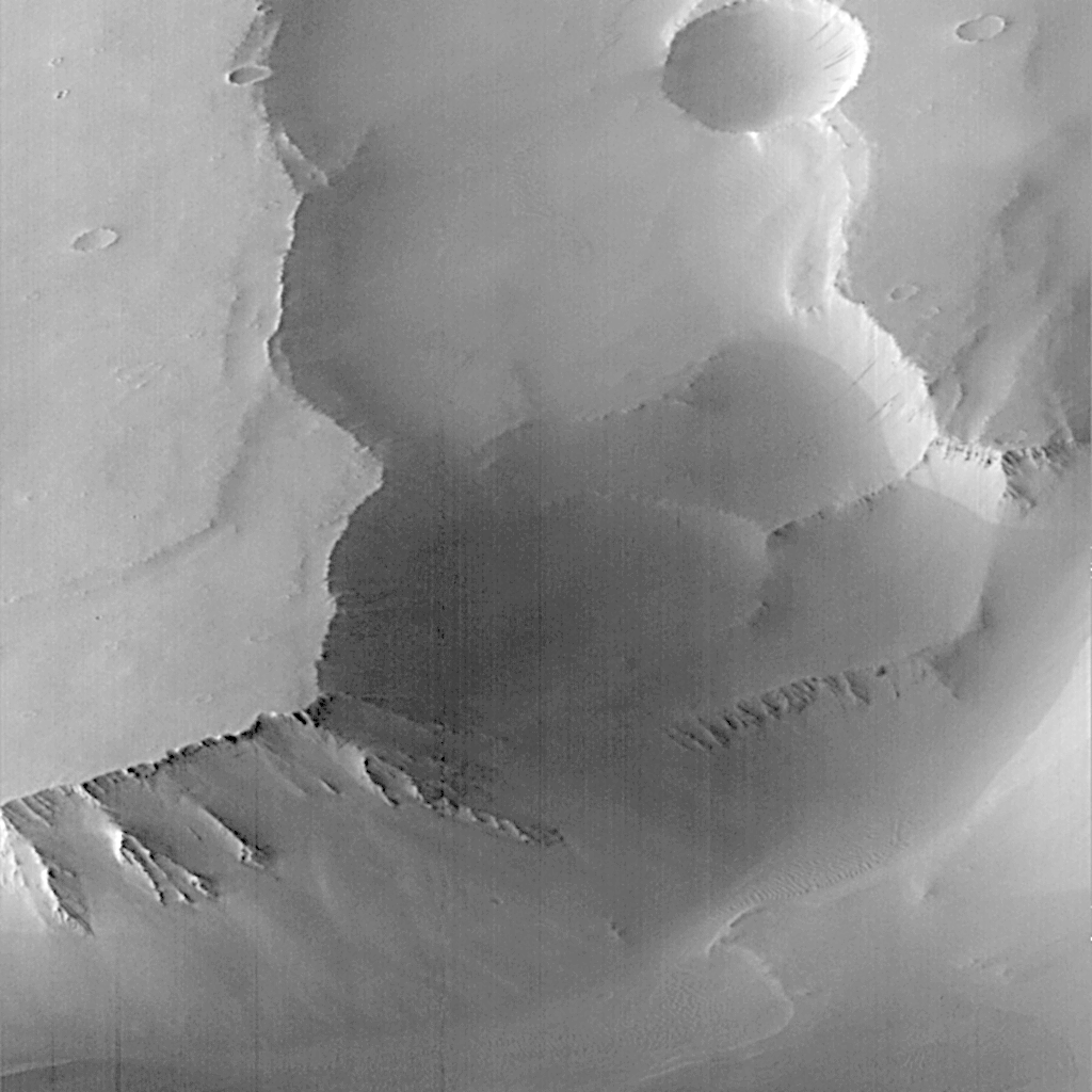

 (B)
(B)