
Mars Global Surveyor Mars Orbiter Camera Release:                   MOC2-5
Mars Global Surveyor Mars Orbiter Camera Image ID:            556458026.11
 Click on image for full resolution version (49KBytes)
Image acquired 8/19/1997 11:40:24 UTC
Camera Aim Point = 23.6°N, 172.4°W
Range = 5.85 Mkm
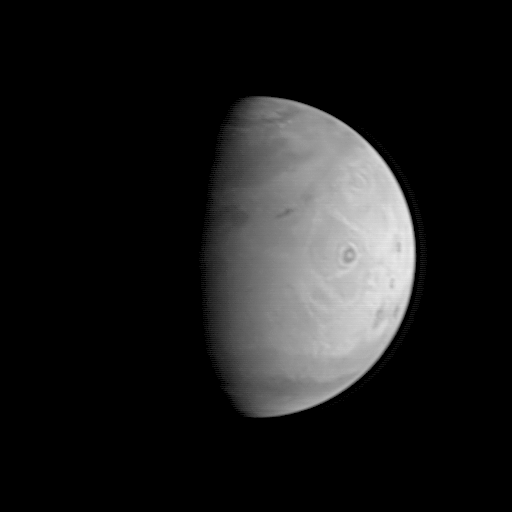
This image is the first of a sequence of Mars to be taken by the Mars Global Surveyor Orbiter Camera (MOC) between August 19 and August 21, 1997. It was acquired early in the morning of August 19 when the MGS spacecraft was 5.8 million kilometers (3.6 million miles) and 24 days from encounter. At this distance, the MOC's resolution is about 21.8 km per picture element, and the 6800 km (4200 mile) diameter planet is about 312 pixels across. The MGS spacecraft pointed the camera at the center of the planet (near the dark, morning sunrise line, or terminator) at 23.6° N, 172.4° W. The image shows Olympus Mons, 25 km (15.5 mile) high, 550 km (340 mile) wide volcano, towards the center of the illuminated portion of the planet, with the three other large Tharsis volcanos appearing as dark spots closer to the bright edge, or limb of the planet. The "bulls-eye" appearance of Olympus Mons is likely the result of the interplay between light-colored dust, dark rock, and clouds and fog. The central spot is the light, dust-covered floor of the summit crater (called the caldera), the dark zone is the rocky, less dust-covered upper slope of the volcano, and the outer bright ring is the lower, dust, fog, and cloud covered lower slopes of the volcano. A faint indication of the 3 km high escarpment that surrounds the base of Olympus Mons can be seen as a thin dark line on the outer edge of the bright outer zone. Many of the wispy light areas seen throughout this image are probably other clouds and morning hazes, which have been prominently seen in Hubble Space Telescope images taken this year. The north polar residual ice cap, surrounded by a dark annulus of sand, is seen at the top of this picture.
|
Click Here for more information on MGS data release and archiving plans. |
Contact: info@msss.com
 Return to MSSS Home Page