Mars Global Surveyor
Mars Orbiter Camera
Mars Orbiter Camera (MOC) High Resolution Images:
July 4, 1998
Mars Pathfinder First Anniversary Special--
Refined Landing Site Location in MOC Image 25603
Mars Global Surveyor Mars Orbiter Camera Release:          MOC2-56a, -56b, -56c, -56d, -56e
Mars Global Surveyor Mars Orbiter Camera Image ID:         552348805.20 (global NA image);
							   577743128.25603 (high resol. NA image)
                                                           P256-03
(A)
63 KByte GIF image
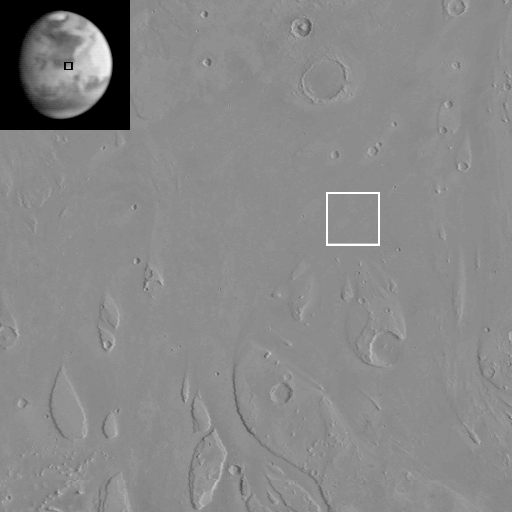
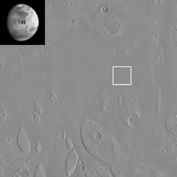
(A) Global and regional setting of Mars Pathfinder's July 4, 1997,
landing site. Inset is the first image of Mars obtained by MGS MOC
on July 2, 1997, at a distance of 17.2 million kilometers (10.7 million
miles) from the planet. The black box indicates the Ares Vallis
region where Mars Pathfinder was scheduled to land 2 days later.
The regional view is part of a U.S. Geological Survey Viking
orbiter photomosaic 1:64-scale map. The white box indicates the
general region into which Mars Pathfinder landed. The wide, straight
valley entering the map from the lower right is Ares Vallis. North
is up in both images. Note that the black and white boxes do
not correspond to the size of any subsequent pictures-- they
are designed to merely show general locations.
(B)

463 KByte GIF image
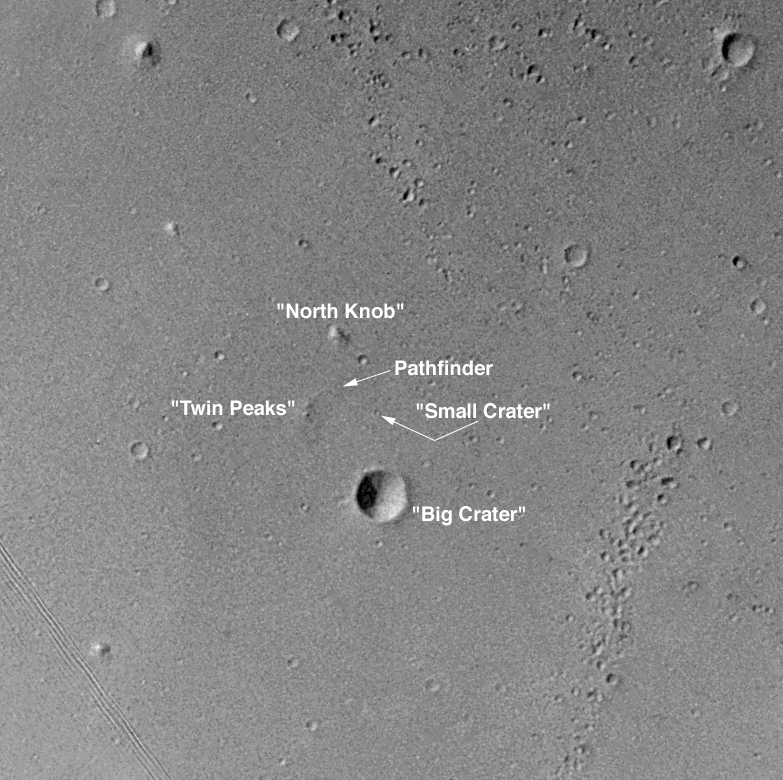
(B) Subsection of Viking 1 Orbiter image 004a70, which was taken in
June 1976, to support landing site selection for the earlier, Viking mission.
The features labeled here were visible from the Mars Pathfinder
lander on its July 4, 1997, landing. These features allowed the
Mars Pathfinder team to quickly identify the location of the
lander in the Ares Vallis setting. Image has been map-projected
so that north is up. Illumination is from the upper left.
Prior to the Mars Global Surveyor mission, this was the
highest-resolution image of the area. Image resolution
is about 27 meters (89 feet) per pixel.
(C)
389 KByte GIF image
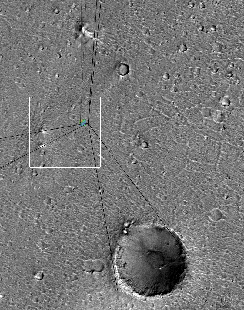
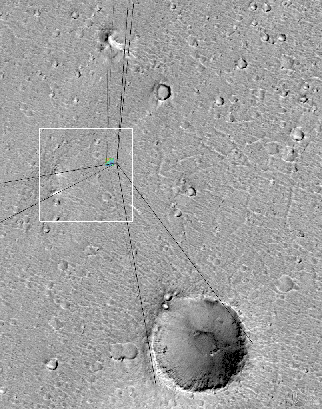
(C) MOC image 25603 subframe, shown at 5.9 meters (about 19 feet)
per pixel resolution. Small, colored box is a topographic map of the
Mars Pathfinder landing site produced by the U.S. Geological Survey
(Flagstaff, AZ) from Mars Pathfinder stereographic images (see
subsequent 2 pictures for a higher-resolution view). Dark, heavy lines
are "sightlines" to various landmarks seen along the horizon in Mars
Pathfinder camera images, measured by T. Parker of the Jet Propulsion
Laboratory and matched to features seen in Viking Orbiter images.
These lines were published in Science, v. 278, p. 1746, December 5,
1997. The lighter, thinner sightlines are the same lines, adjusted
to match the same features as seen in the higher resolution MOC image
25603. These lines indicate the location of the landing site to
within a few hundred meters/yards. The colored box--the topographic
map--has been placed at the location of the actual landing site (see
images below). The lander and rover would be located at the center of
the colored box. The white box shows the context of image (D), below.
North is up, illumination is from the lower right.
(D)
207 KByte JPEG image
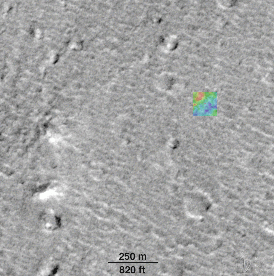
(D) Location of Mars Pathfinder lander and Sojourner Rover,
relative to Mars Global Surveyor MOC image obtained April 1998. The
famous "Twin Peaks"-- first seen by the lander on July 4, 1997--are
shown at the lower left. The scale bar indicates distance in feet and
in meters. The colored box is the topographic map of the Mars
Pathfinder landing site, derived from Pathfinder camera stereoscopic
images by R. Kirk and colleagues at the U.S. Geological Survey
(Flagstaff, AZ). The lander and rover were located in the center of
the colored box. An explanation of the colors is given below in (E).
(E)
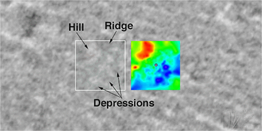
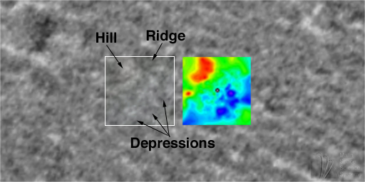
71 KByte JPEG image
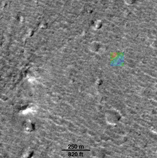
(E) Location of Mars Pathfinder landing site in MOC image 25603. The
lander is located in the center of the white box. The original
resolution of the MOC image was about 3.3 meters (11 feet) per pixel;
however, because the region was hazy at the time the picture was
taken, the effective resolution is only about 5 meters (16.4 feet) per
pixel. Thus, the lander and rover are too small to actually be seen
in the image. The colored box, 120 m (just under 400 ft) on a side,
is the topographic map of the landing site. The topographic map was
made using the stereographic images taken by Mars Pathfinder in 1997.
Low areas--depressions--are blue and purple, high areas--hill--are
shown as red. The range of heights is actually fairly small--a total
of 4 m (about 13 ft) from dark purple to bright red. The lander is
represented within the black dot at the center of the map. A
preliminary version of the topographic map that is generally similar
to this more refined version was published in Science, v. 278, p.
1736, December 5, 1997.
You may need to adjust the images for the gamma of your monitor to
insure proper viewing.
|
Note: This MOC image is made available
in order to share with the public the excitement of new
discoveries being made via the Mars Global Surveyor spacecraft.
The image may be reproduced only if the
image is credited to "Malin Space Science Systems/NASA".
Release of this image does not constitute a release of
scientific data. The image and its caption should not be
referenced in the scientific literature. Full data releases
to the scientific community are scheduled by the Mars Global
Surveyor Project and NASA Planetary Data System. Typically, data
will be released after a 6 month calibration and validation period.
Click Here for more information on MGS data release and
archiving plans.
|
CAPTION
It has been one year since NASA's Return to the Red Planet began with
the spectacular landing of Mars Pathfinder and its microrover, Sojourner.
The spacecraft bounced onto a flood-washed landscape on July 4, 1997.
Mars Pathfinder was soon joined by the orbiting Mars Global Surveyor on
September 11, 1997 (PDT). Mars Global Surveyor's high resolution camera,
MOC, took a picture of the Mars Pathfinder landing site region during its
256th orbit on April 22, 1998. This picture--at about 5 meters (11 feet)
per pixel--is the best available for the site. The previous best
images were from the Viking 1 Orbiter in 1976, and had resolutions of
about 38 meters (125 feet) per pixel.
The MOC image has allowed scientists to determine the exact location
of the Mars Pathfinder lander. Unfortunately, the image resolution
is not good enough to actually see the lander--nor can any of
the familiar boulders (e.g., "Yogi") be seen at this resolution.
Using the MOC image, the landing site location has been refined by Dr.
Michael Malin, Principal Investigator for the Mars Global Surveyor MOC
Team and a Participating Scientist on the Mars Pathfinder mission.
The images (C), (D), and (E), above, illustrate
how the landing site was located by using the "sightlines" published
by T. Parker (Jet Propulsion Laboratory, Pasadena, CA) and topographic
map kindly provided in advance of publication by R. Kirk (U.S.
Geological Survey, Flagstaff, AZ).
For more information on the MOC images of the Mars Pathfinder landing site,
see:
Malin Space Science Systems and the California Institute of
Technology built the MOC using spare hardware from the Mars Observer
mission. MSSS operates the camera from its facilities in San Diego,
CA. The Jet Propulsion Laboratory's Mars Surveyor Operations Project
operates the Mars Global Surveyor spacecraft with its industrial
partner, Lockheed Martin Astronautics, from facilities in Pasadena, CA
and Denver, CO.
 To MSSS Home Page
Contact: info@msss.com