Mars Global Surveyor
Mars Orbiter Camera
Mars Orbiter Camera (MOC) High and Low Resolution Images
SPO-2 Observations:
Elysium Mons Volcano
Mars Global Surveyor Mars Orbiter Camera Release:          MOC2-57a, -57b, -57c, -57d, -57e, -57f, -57g, -57h
Mars Global Surveyor Mars Orbiter Camera Image ID:         583905525.40301
                                                           P403-01 (Red WA);
							   583905525.40302
							   P403-02 (Blue WA);
							   583905743.40303
							   P403-03 (Hi. Res. NA)
(A)
499 KByte JPG image
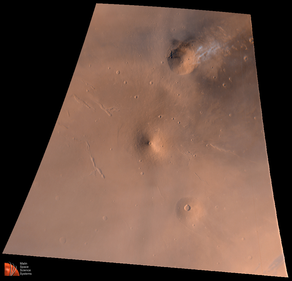
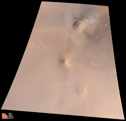
(A) Elysium Volcanic Region as seen by MOC on July 2, 1998.
Volcano near top center is Hecates Tholus--note bright
clouds off its northeast flank. Volcano near center is
Elysium Mons; volcano toward lower right is Albor Tholus.
Red channel is MOC red wide angle image 40301, the blue
channel is MOC blue wide angle image 40302, and the green
channel is synthesized by averaging the red and blue
bands. Image is an orthographic projection centered at
24.85°N, 213.25°W. The scale at the center of
the projection is 4.65 kilometers (2.9 miles) per pixel.
North is up, illumination is from the lower right.
(B)

1 MByte GIF image
(B) Mariner 9 view of Elysium Mons taken on October 16, 1972, at 11:37
a.m. PST. This is a mosaic of images 676B01 and 676B02 (where the
numbers before the "B"
refer to the Mariner 9 orbit on which the images were taken, the "B"
refers to the Mariner 9 high resolution camera, and the last two
digits indicate the image number on that orbit). North is up,
illumination is from the right. Reproduced in a simple cylindrical
projection at a scale of 75 m/pixel.
(C)
736 KByte JPG image
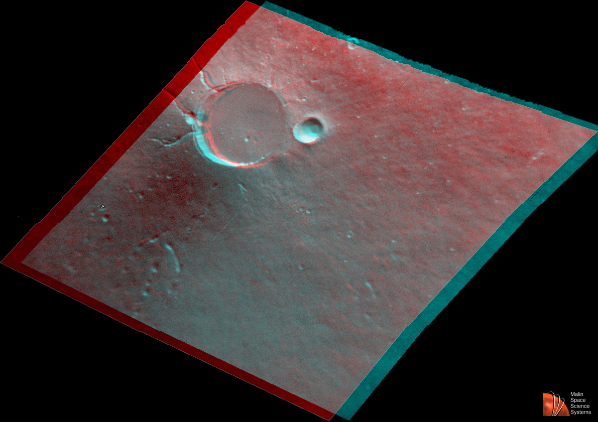
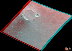
(C) Anaglyph stereo image of Elysium Mons (use red filter for left eye), constructed from
Mariner 9 high resolution B-frame images. Two images were taken
9 months apart by Mariner 9 in 1972 to provide this high-resolution,
stereoscopic view of the summit of Elysium Mons. The first image
(134B31), acquired on January 19, 1972, at 4:12 p.m. PST, was
taken at
a viewing angle of 19° from vertical, while the second image
(676B01) was acquired on October 16, 1972, at 11:37 a.m. PST. The
image scale is roughly 80 m/pixel.
(D)
1.2 MByte GIF image
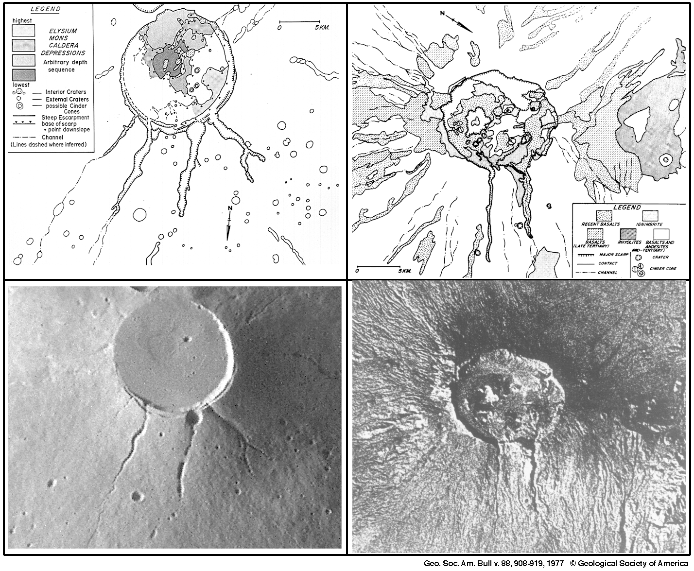
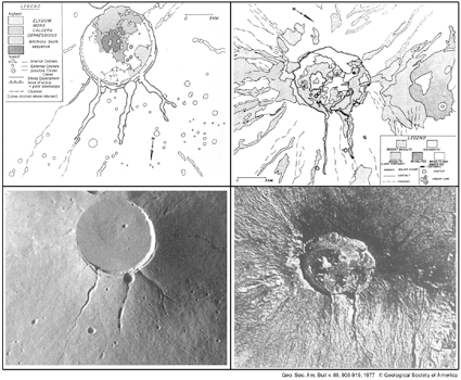
(D) Comparison of Elysium Mons summit and upper flanks with
the summit and flanks of Emi Koussi volcano in Chad on
the continent of Africa. The Elysium Mons picture is from
Mariner 9, the Emi Koussi picture was taken by an astronaut
on Apollo 7 (Frame # 5-1621) in 1968. The two volcanoes show many
similarities. Both have an approximately circular caldera--
the central crater at the summit-- with evidence of two
caldera collapse events. Both have deep channels incised
into the caldera rim and upper flanks--the channels developed
as a result of faulting followed by lava which poured
through them. The two volcanoes are different in one
important aspect, however--water runoff (e.g., from rain) has
formed many channels on the lower flanks of Emi Koussi, but
no such channels formed on Elysium Mons (i.e., it never rained on
Elysium Mons). This figure and further details on the comparison
of these two volcanoes were published by MOC Principal Investigator
Michael C. Malin, "Comparison of volcanic features of Elysium
(Mars) and Tibesti (Earth)," Geological Society of America
Bulletin, v. 88, p. 908-919, 1977.
(E)

24 KByte GIF image
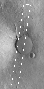
(E) Elysium Mons summit region. White box shows location
of MOC narrow angle image 40303 (below). Base map is
U.S. Geological Survey Viking photomosaic at 1:256 scale.
North is up, illumination is from the left.
(F)

780 KByte GIF image
(F) MOC image 40303, shown at 25% of its original size.
North is approximately up, illumination is from the right.
Resolution of picture shown here is 21 meters (69 feet)
per pixel. Image was received with bright slopes saturated at DN=255.
(G)

733 KByte GIF image
(G) MOC image 40303, shown at 25% of its original size, same
as above in (F), except shown here with a box that
indicates the location of the full-resolution subframe
shown below in (H).
(H)
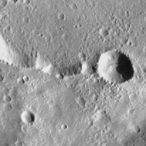
244 KByte GIF image
(H) MOC image 40303 subframe of the Elysium Mons'
southern caldera wall and floor shown at
full resolution (5.24 meters (17.2 feet) per pixel).
Illumination is from the right, north is approximately up.
You may need to adjust the images for the gamma of your monitor to
insure proper viewing.
|
Note: This MOC image is made available
in order to share with the public the excitement of new
discoveries being made via the Mars Global Surveyor spacecraft.
The image may be reproduced only if the
image is credited to "Malin Space Science Systems/NASA".
Release of this image does not constitute a release of
scientific data. The image and its caption should not be
referenced in the scientific literature. Full data releases
to the scientific community are scheduled by the Mars Global
Surveyor Project and NASA Planetary Data System. Typically, data
will be released after a 6 month calibration and validation period.
Click Here for more information on MGS data release and
archiving plans.
|
CAPTION
On July 4, 1998---the first anniversary of the Mars Pathfinder landing---
Mars Global Surveyor's latest images were radioed to Earth with little
fanfare. The images received on July 4, 1998, however, were very exciting
because they included a rare crossing of the summit caldera of a major
martian volcano.
Elysium Mons is located at 25°N, 213°W, in the martian eastern
hemisphere. As shown in Figure (A), above, Elysium Mons is one of three
large volcanoes that occur on the Elysium Rise-- the others are
Hecates Tholus (northeast of Elysium Mons) and Albor Tholus (southeast
of Elysium Mons). The volcano rises about 12.5 kilometers (7.8 miles)
above the surrounding plain, or about 16 kilometes (9.9 miles) above
the martian datum-- the "zero" elevation defined by average
martian atmospheric pressure and the planet's radius.
Elysium Mons was discovered by Mariner 9 in 1972. It differs in a
number of ways from the familiar Olympus Mons and other large
volcanoes in the Tharsis region. In particular, there are no obvious
lava flows visible on the volcano's flanks. The lack of lava flows
was apparent from the Mariner 9 images, but the new MOC high
resolution image--obtained at 5.24 meters (17.2 feet) per
pixel--illustrates that this is true even when viewed at higher
spatial resolution.
Elysium Mons has many craters on its surface. Some of these probably
formed by meteor impact, but many show no ejecta pattern
characteristic of meteor impact. Some of the craters are aligned in
linear patterns that are radial to the summit caldera--these most
likely formed by collapse as lava was withdrawn from beneath the
surface, rather than by meteor impact. Other craters may have formed
by explosive volcanism. Evidence for explosive volcanism on Mars has
been very difficult to identify from previous Mars spacecraft images.
This and other MOC data are being examined closely to better
understand the nature and origin of volcanic features on Mars.
The three MOC images, 40301 (red wide angle), 40302 (blue wide angle),
and 40303 (high resolution, narrow angle) were obtained on Mars Global
Surveyor's 403rd orbit around the planet around 9:58 - 10:05 p.m. PDT
on July 2, 1998. The images were received and processed at Malin
Space Science Systems (MSSS) around 4:00 p.m. PDT on July 4, 1998.
Malin Space Science Systems and the California Institute of
Technology built the MOC using spare hardware from the Mars Observer
mission. MSSS operates the camera from its facilities in San Diego,
CA. The Jet Propulsion Laboratory's Mars Surveyor Operations Project
operates the Mars Global Surveyor spacecraft with its industrial
partner, Lockheed Martin Astronautics, from facilities in Pasadena, CA
and Denver, CO.
 To MSSS Home Page
Contact: info@msss.com