
MGS MOC Release No. MOC2-137 and MOC2-138, 25 June 1999
Because MOC images only cover a tiny fraction of one percent of the surface of Mars, we have been seeking general correlations that exist between what is seen in a MOC high-resolution image and what can be seen in the lower-resolution Viking and Mariner 9 images taken in 1972 and 1976-1980.
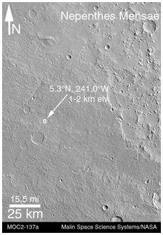
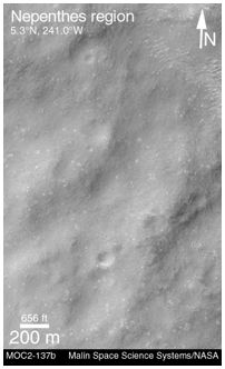
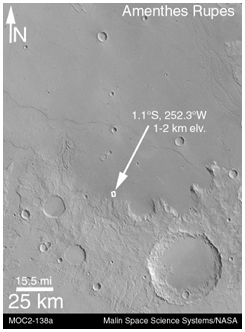
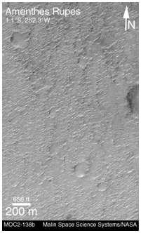
The most important results thus far are illustrated in the four pictures above. Nearly 70% of the terrain examined follows two very simple, but unexpected "rules" -- (1) If the terrain appears rugged at the hundreds of meters to kilometers scale in a Viking or Mariner image, then it will appear smooth at the meter-scale in a MOC image. (2) If the terrain appears to be smooth in the Viking or Mariner image, it will be rough in the meter-scale MOC image.
The first pair of pictures above illustrates the first "rule." MOC2-137a (top, left) shows a rugged plain in the martian southern cratered highlands near the Nepenthes Mensae. The small white box indicates the location of the MOC image, which is on the top right (MOC2-137b). The MOC image reveals that while the terrain is rough at the large scale, it is quite smooth at the meter-scale.
The second pair of images illustrates the second "rule." Areas that appear to be smooth in the Viking and Mariner images--as in MOC2-138a (bottom, left)--tend to look quite rough at the meter scale in MOC images like MOC2-138b (bottom, right). The rough texture in this particular case was probably cause by wind erosion.
Both Viking images shown here are illuminated from the upper right, while the MOC images are illuminated from the upper left. The MOC images were taken in April 1999, while the Viking images were obtained in the late 1970s. More details about this work are provided in an extended abstract (in Acrobat® PDF format) by M. C. Malin, K. S. Edgett, and T. J. Parker, "Characterization of terrain in the Mars Surveyor 2001 landing site latitude and elevation region using Mapping Phase Mars Global Surveyor MOC images," presented at the Second Mars Surveyor Landing Site Workshop, held June 22-23, 1999, in Buffalo, New York.
Malin Space Science Systems and the California Institute of Technology built the MOC using spare hardware from the Mars Observer mission. MSSS operates the camera from its facilities in San Diego, CA. The Jet Propulsion Laboratory's Mars Surveyor Operations Project operates the Mars Global Surveyor spacecraft with its industrial partner, Lockheed Martin Astronautics, from facilities in Pasadena, CA and Denver, CO.
Contact: info@msss.com
 To MSSS Home Page