Mars Global Surveyor
Mars Orbiter Camera
MOC Views Viking Lander 1 Site Through Dust Storm Clouds
Mars Global Surveyor Mars Orbiter Camera Release:          MOC2-42A, -42B, -42C, -42D, -42E
Mars Global Surveyor Mars Orbiter Camera Image ID:         576862308.23501 (P235-01 WA Red)
                                                           576862308.23502 (P235-02 WA Blue)
                                                           576862349.23503 (P235-03 NA image)
Shortly after 08:32 PDT on 12 April 1998, the Mars Global Surveyor
spacecraft pointed the Mars Orbiter Camera (MOC) towards the location
of the Viking Lander 1 near 22.48° N, 47.97° W. During
acquisition of the 2.7 meter (8.8 foot) per pixel (projected
resolution) image, the spacecraft was about 640 km from the site,
viewing down from space at an angle of 31.64 °. The local
illumination conditions at the time were equivalent to a local martian
solar time of 9:20 AM.

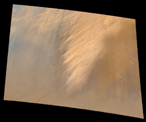
MOC 23501 (red) and 23502
(blue) Wide Angle Context Image
(showing location of MOC 23503) (JPEG =
825 KB)
The figure above shows the wide-angle view of the region during the
orbit 235 observations. This view, a map projection, shows an image
area of about 310 km wide by 290 km, at a scale of 300 meters (985
feet) per pixel. The green channel of this image was synthesized from
the red and blue channels. Noted by a white box is the outline of the
MOC high resolution (narrow angle) image (MOC 23503).
A well-developed local dust storm dominates this view of the planet.
Plumes from the storm suggest that the wind is blowing from lower left
to wards the upper right. The slightly dark zone around the dust
cloud may be surface that has been swept clean of a fraction of the
mobile dust. The dust cloud obscures most of the landing site as seen
in this image.

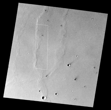
Viking Orbiter 027A63
showing location of MOC 23503 (GIF = 2.2 MB)
This figure shows the location of the MOC high resolution image, as
seen on a Viking Orbiter frame. The map-projected VO frame (027A63)
shown here has a displayed scale of 28 meters (92 feet) per pixel.
The Viking image was acquired on 17 July 1976 at 3:07 AM PDT.
The Viking Lander 1 site is on a relatively smooth plain in Chryse
Planitia. Seen in this Viking image are two important attributes of
this location: brightness "streaks" associated with impact craters and
irregular, almost sinuous ridges. The dark streaks pointing towards
the northeast are consistent with the direction of winter, downslope
winds (as seen in the present dust storm). Such dark streaks usually
develop as light-colored dust is kicked up by turbulence behind the
crater and then transported away by the wind. The ridges are believed
to reflect tectonic forces associated with the ground's adjustment to
the weight of material filling the Chryse basin. The origin of the
fill is not certain: it may be lava flows, flood debris, or both.

MOC 23503 full frame at 1/8th resolution (GIF = 283 KB)
This figure shows the MOC image 23503 at roughly the same scale as the
Viking image (22 meters, or 71 feet, per pixel). Remarkably, despite
the cloudiness seen in the low resolution wide-angle images,
considerable surface detail is visible. The MOC image shows two
phenomena associated with the dust cloudy atmosphere--a reduction in
contrast caused by the haziness of the atmosphere and a light and dark
mottling that reflects local variations in cloud thickness (not
particularly the light patches at the extreme top and bottom of the
image). Note that this version of the image has been processed to
enhance both small detail while trying to retain the overall
brightness variations. The dark band near the center of the image
represents data lost during the tranmsission and transport of the
image to Malin Space Science Systems.
 <
<

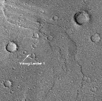
(Left) Mosaic of Viking Orbiter 452B11 (left) and 452B10 (right) (GIF = 292 KB)
(Right) MOC 23503 (partial frame) (GIF = 2.13 MB)
The left-hand image, above, is a section out of a mosaic of two Viking
Orbiter very high resolution images, also taken under
less-than-optimum illumination and atmospheric conditions. The two
Viking frames (452B10 and 452B11) were map-projected to a common scale
of 7 meters (22.8 feet) per pixel and portions mosaicked. The white
arrow points to the approximate position of the lander, as determined
by Morris and Jones (Icarus 44, 217-222, 1980) from
matching features seen in lander images with features seen in these
orbiter pictures. Owing to atmospheric hazes and some residual
spacecraft motion-blur, the effective scale of these images is
probably between 10 and 12 meters (33 and 40 feet) per pixel.
The right-hand view, above, is a section of MOC narrow angle frame
23503 that covers the same area as seen in the highest resolution
Viking images. This map-projected picture has a scale of 2.7 meters
(9 feet) per pixel. However, defocus of the camera and, more
importantly, atmospheric haze, reduces the effective scale of this
image to about 4 meters (13 feet) per pixel. This scale is
insufficient to resolve the Viking Lander, and the image shows no
indication of the presence of the lander. The scale is also marginal
for distinguishing large rocks. Some can be seen as part of the
ejecta of the larger craters in the scene (especially around the fresh
crater about a kilometer to the west of the landing site). Although
the MOC image is about 3 times higher resolution than the Viking
image, the combination of non-vertical viewing, the less-than-optimum
illumination conditions, and the substantial atmospheric contribution
to image degradation, all lead to an image that does not address the
major outstanding questions regarding the site. Images acquired
if the spacecraft passes over the landing site during the
mapping mission will be substantially better.
|
Note: The MOC images are made available
in order to share with the public the excitement of new
discoveries being made via the Mars Global Surveyor spacecraft.
The images may be reproduced only if the
images are credited to "Malin Space Science Systems/NASA".
Release of an image does not constitute a release of
scientific data. An image and its caption should not be
referenced in the scientific literature. Full data releases
to the scientific community are scheduled by the Mars Global
Surveyor Project and NASA Planetary Data System. Typically, data
will be released after a 6 month calibration and validation period.
Click Here for more information on MGS data release and
archiving plans.
|

