
MGS MOC Release No. MOC2-192, 2 December 1999
To give some sense of the nature of polar terrain in the vicinity of Mars Polar Lander's 76°S, 195°W landing zone, very high resolution MOC images are here compared with the "main campus" of the Jet Propulsion Laboratory (JPL). JPL is located in Pasadena, California, and is part of the California Institute of Technology (Caltech). Together with partners Lockheed Martin Astronautics (Denver, CO), University of California-Los Angeles, The Planetary Society (Pasadena, CA), and Malin Space Science Systems (San Diego, CA), JPL is operating and managing the Mars Polar Lander and Deep Space 2 missions under contract from NASA.
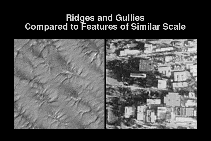
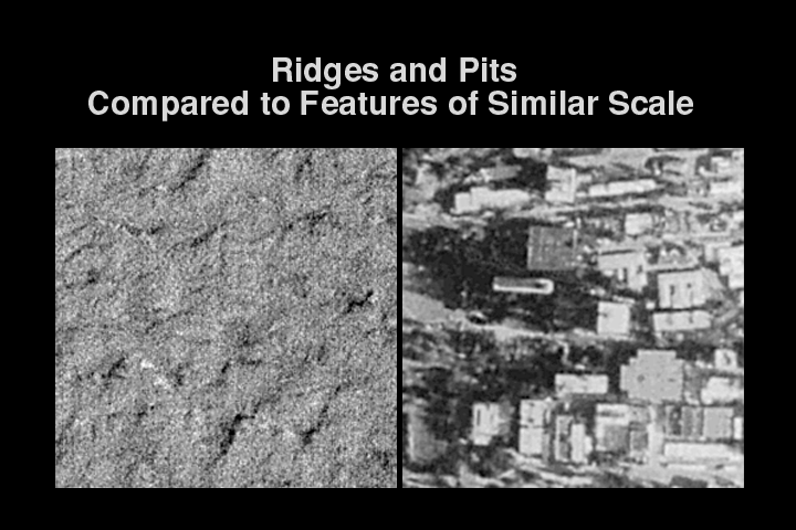
The three MOC images shown next to each view of JPL represent the three most abundant terrain types seen in the Mars Polar Lander landing ellipse--ridges and small knobs, ridges and gullies, and ridges and pits. Each is shown at the same scale as the buildings of the Jet Propulsion Laboratory (1.5 m/pixel). Each image is about 400 meters (437 yards) across and is illuminated by sunlight from the lower right.

|
MOC2-192aSubtle Ridges and Small Knobs Compared to Features of Similar Scale The picture on the left is a MOC image taken in mid-November 1999 near the west edge of Mars Polar Lander's landing ellipse. Many small, bright pinnacles or knobs are visible amid a few circular features and dark patches. The picture on the right shows a portion of the Jet Propulsion Laboratory at the same scale. Note that buildings and some trees can be discerned in the JPL photo.
|
|
MOC2-192bRidges and Gullies Compared to Features of Similar Scale Taken in November 1999 after the winter frost had finally cleared away, this view of typical ridged and gullied terrain in the Mars Polar Lander ellipse (left) is compared at the same scale with the buildings of the Jet Propulsion Laboratory (right). A person standing in one of the gullies or cracks in the polar terrain would certainly notice that they are down in a hole! |
|
MOC2-192cRidges and Pits Compared to Features of Similar Scale The image on the left shows a third sample of terrain in the Mars Polar Lander landing zone. This picture was acquired in mid/late November 1999 after the seasonal frost had sublimed away. The terrrain appears rugged but not nearly as rugged as the artificial terrain of buildings and sidewalks at the Jet Propulsion Laboratory (right). |
Also see:
"Geologic Features of the Mars Polar Lander Landing Ellipse," December 2, 1999
"Latest Color View of Polar Landing Site," December 2, 1999
"Layers of the South Polar Layered Deposits," November 22, 1999
"Mars Global Surveyor Views of the Mars Polar Landing Site," August 25, 1999
Malin Space Science Systems and the California Institute of Technology built the MOC using spare hardware from the Mars Observer mission. MSSS operates the camera from its facilities in San Diego, CA. The Jet Propulsion Laboratory's Mars Surveyor Operations Project operates the Mars Global Surveyor spacecraft with its industrial partner, Lockheed Martin Astronautics, from facilities in Pasadena, CA and Denver, CO.
 To MSSS Home Page