
Mars Global Surveyor Mars Orbiter Camera Release:          MOC2-68a, -68b, -68c
Mars Global Surveyor Mars Orbiter Camera Image ID:         581474713.34504
							   P345-4
|
Click Here for more information on MGS data release and archiving plans. |
CAPTION
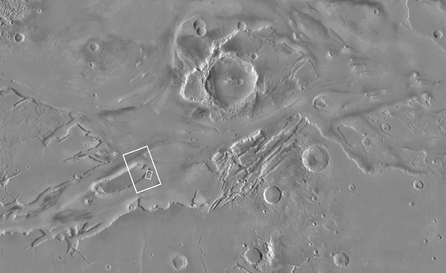
Mars Global Surveyor's high resolution Mars Orbiter Camera (MOC) is providing scientists with a whole new way of looking at Mars. Able to see objects down to the size of automobiles and houses, results from the first year of MOC operations are suggesting that the red planet has had a complicated history that was very different from that of the only two places that geologists have visited in person: the Earth and the Moon.An example of the complexity of martian geologic history is shown by a crater in Kasei Vallis that was imaged during the 345th orbit of Mars Global Surveyor at 5:44 p.m. PDT on June 4, 1998. MOC image 34504 (see (C), above) shows a 6 kilometer- (4 mile)- diameter crater that was once buried by about 3 kilometers (2 miles) of martian "bedrock."
Kasei Vallis is actually a system of giant channels thought to have been carved by catastrophic floods that occurred more than a billion years ago. A similar scenario was proposed to explain the Ares Vallis channel, where Mars Pathfinder landed in July 1997.
The Kasei Valles floods carved a deep and wide system of channels into the northern portion of Lunae Planum--a vast, relatively flat plain made up of layered rock that formed some time before the floods.
The crater shown above was partly excavated by the Kasei Valles floods. The crater is poking out from beneath an "island" in the Kasei Valles. The mesa was created in part by the flood, and by subsequent retreat--by small landslides--of the scarp that encircles it. A "moat" or trench partly encircles the crater to the west and south. This moat formed were the turbulence of the floodwaters interacting with the obstacle represented by the crater rim eroded material in front of, and along the side, of the crater. The rim was too high for the flood to overtop, and the flood lasted too short a time for the erosion to breach the crater rim and destroy it.
The crater seen here was most likely formed early in Mars history, perhaps as long as 3.5 billion years ago. Sometime after it formed by meteor impact, it was buried by the material that comprises Lunae Planum (the large plains unit of which the island appears to be part). The material composing the island is, at least in places, hard rock, since the brink of the cliff is sharp and the erosional ridges that extend down from the brink stand out in sharp relief. However, the processes that emplaced the rock were sufficiently gentle that the crater was not destroyed by that emplacement, nor by the burial. In that respect, the crater is like a giant fossil. Likewise, the process or processes that exposed the crater--the Kasei floods and retreat of the mesa scarp--were also sufficiently "gentle" so that much of the crater's original appearance has been preserved.
This exhumed crater is one of many seen by MOC during its first year of operations. This particular crater was first suspected to have been exhumed when it was seen in images from Mariner 9 in 1972. The close-up view provided by MOC confirms that the crater has emerged from beneath the mesa, and that it suffered little damage from the Kasei floods.
Malin Space Science Systems and the California Institute of Technology built the MOC using spare hardware from the Mars Observer mission. MSSS operates the camera from its facilities in San Diego, CA. The Jet Propulsion Laboratory's Mars Surveyor Operations Project operates the Mars Global Surveyor spacecraft with its industrial partner, Lockheed Martin Astronautics, from facilities in Pasadena, CA and Denver, CO.
Contact: info@msss.com
 To MSSS Home Page